IMAGES TAKEN NEAR TO
Dale Grove, LEYBURN, DL8 5JG
Introduction
This page details the photographs taken nearby to Dale Grove, DL8 5JG by members of the Geograph project.
The Geograph project started in 2005 with the aim of publishing, organising and preserving representative images for every square kilometre of Great Britain, Ireland and the Isle of Man.

There are currently over 7.5m images from over14,400 individuals and you can help contribute to the project by visiting https://www.geograph.org.uk
Image Map (Loading...)


Getting Data...Please wait
Leaflet Map data © OpenStreetMap
Images are licensed for reuse under creativecommons.org/licenses/by-sa/2.0
Notes
- Clicking on the map will re-center to the selected point.
- The higher the marker number, the further away the image location is from the centre of the postcode.
Image Listing (19 Images Found)
Images are licensed for reuse under creativecommons.org/licenses/by-sa/2.0
Image
Details
Distance
1
Looking south down Rumford Way, from the corner of Dale Grove
This estate was built in the early 2000s but doesn't seem to have appeared yet on the 1:50000 map (but it is present on the 1:25000 map).
Image: © C P Smith
Taken: 26 Dec 2010
0.02 miles
2
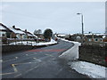
Dale Grove, Leyburn, looking west from the corner of Rumford way
This picture shows the earliest part of Dale Grove to be built. The road continues east into an estate constructed in the early 2000s. Dale Grove is the estate's main link to the outside world.
Image: © C P Smith
Taken: 26 Dec 2010
0.03 miles
3
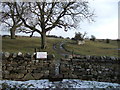
Leyburn - stile on the Dale Grove estate
This stile gives access from the Dale Grove estate (for the most part built since and thus not shown on the last update to the 1:50000 map [2002]) to the footpath to High Side and thence, via a track, to Harmby.
Image: © C P Smith
Taken: 8 Jan 2011
0.08 miles
4
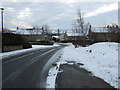
Looking north up the A6108 Bellerby Road, Leyburn
Image: © C P Smith
Taken: 26 Dec 2010
0.09 miles
5
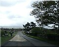
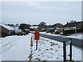
Entering Leyburn on Bellerby Road
On an overcast day
Image: © Martin Dawes
Taken: 23 Apr 2024
0.10 miles
6
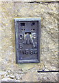
Ordnance Survey Flush Bracket 11586
This can be found on the wall of a private house in Richmond Road.
For more detail see : http://www.bench-marks.org.uk/log?bm_key=11876
Image: © Peter Wood
Taken: 17 Jul 2013
0.16 miles
7
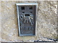
Benchmark on 'Prospect Villa'
Ordnance Survey flush bracket (serial number 11586) benchmark on side of the house described on the Bench Mark Database at http://www.bench-marks.org.uk/bm11876
Image: © Roger Templeman
Taken: 30 Aug 2012
0.17 miles
8
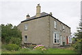
Prospect Villa, Richmond Road (A6108)
There is an OS flush bracket Image visible on the facing corner of the house
Image: © Roger Templeman
Taken: 30 Aug 2012
0.17 miles
9
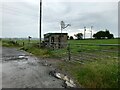
Gas monitoring/control station, Bellarby Road
Just off the A6108 Bellarby Road, between Leyburn and Bellarby. Brick building has an attached notice referring to it as a “gas installation”
Image: © David Dixon
Taken: 4 Jul 2021
0.19 miles
10
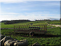
A Farm Trailer
In a field beside the A6108.
Image: © Roger Gilbertson
Taken: 19 Nov 2006
0.19 miles