IMAGES TAKEN NEAR TO
Moor Road, LEYBURN, DL8 5DJ
Introduction
This page details the photographs taken nearby to Moor Road, DL8 5DJ by members of the Geograph project.
The Geograph project started in 2005 with the aim of publishing, organising and preserving representative images for every square kilometre of Great Britain, Ireland and the Isle of Man.

There are currently over 7.5m images from over14,400 individuals and you can help contribute to the project by visiting https://www.geograph.org.uk
Image Map
Images are licensed for reuse under creativecommons.org/licenses/by-sa/2.0
Notes
- Clicking on the map will re-center to the selected point.
- The higher the marker number, the further away the image location is from the centre of the postcode.
Image Listing (53 Images Found)
Images are licensed for reuse under creativecommons.org/licenses/by-sa/2.0
Image
Details
Distance
1
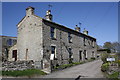
Cottages and access road to Hill Top Farm, Moor Road
The near cottage is West Cottage. Old maps of 1893 and 1981 show a benchmark at the left hand side of the access road, presumably on a stone gatepost which has been lost to farm access road widening. Ordnance Survey records indicate that a mark levelled at 225.308m above Newlyn Datum was verified in 1954 on a gatepost 2.1m from the house corner
Image: © Roger Templeman
Taken: 2 May 2013
0.04 miles
2
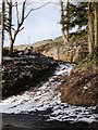
Steep track off Moor Road, Leyburn
A substantial retaining wall has been required above the bend in this track, which appears to lead to a house.
Image: © Christine Johnstone
Taken: 22 Feb 2010
0.05 miles
3
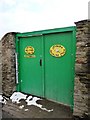
Entrance to Leyburn Bowling Club, Moor Road
Visitors are encouraged to come in and rest awhile, but the tall gates look quite forbidding.
Image: © Christine Johnstone
Taken: 22 Feb 2010
0.07 miles
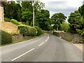
5
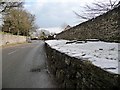
Snow-covered bank, Moor Road, Leyburn
Oddly, this built-up road has a low walled bank alongside it, rather than a pavement.
Image: © Christine Johnstone
Taken: 22 Feb 2010
0.09 miles
6
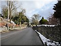
View down Moor Road, towards Leyburn
Image: © Christine Johnstone
Taken: 22 Feb 2010
0.09 miles
7
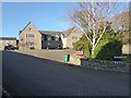
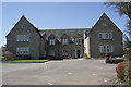
Manor Court, Leyburn
Off the Moor Road.
Image: © Russel Wills
Taken: 18 Jan 2020
0.11 miles
8
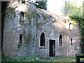
Leyburn Sham Castle
This Sham Castle is behind Thornborough Hall (now the library) and probably formed part of the gardens
Image: © Paul Brooker
Taken: 3 Oct 2009
0.11 miles
9
Manor Court, Moor Road
There is an OS benchmark Image on the near corner, inside face of the left hand wing of the apartments, a former school
Image: © Roger Templeman
Taken: 2 May 2013
0.11 miles
10
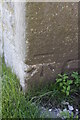
Benchmark on #6 Manor Court
Ordnance Survey cut mark benchmark described on the Bench Mark Database at http://www.bench-marks.org.uk/bm48316
Image: © Roger Templeman
Taken: 2 May 2013
0.12 miles