IMAGES TAKEN NEAR TO
Arkleside, LEYBURN, DL8 4TU
Introduction
This page details the photographs taken nearby to Arkleside, DL8 4TU by members of the Geograph project.
The Geograph project started in 2005 with the aim of publishing, organising and preserving representative images for every square kilometre of Great Britain, Ireland and the Isle of Man.

There are currently over 7.5m images from over14,400 individuals and you can help contribute to the project by visiting https://www.geograph.org.uk
Image Map (Loading...)


Getting Data...Please wait
Leaflet Map data © OpenStreetMap
Images are licensed for reuse under creativecommons.org/licenses/by-sa/2.0
Notes
- Clicking on the map will re-center to the selected point.
- The higher the marker number, the further away the image location is from the centre of the postcode.
Image Listing (10 Images Found)
Images are licensed for reuse under creativecommons.org/licenses/by-sa/2.0
Image
Details
Distance
1
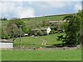
Sowersett and Brackenrigg
Two farm houses on the hillside above Arkleside.
Image: © Gordon Hatton
Taken: 18 May 2021
0.04 miles
2
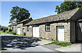
Buildings at Arkleside
Arkleside is a tiny settlement in Coverdale just south of Horsehouse and off the main valley road. These buildings are surely part of Arkleside Farm with the most distant one being the farmhouse.
Image: © Trevor Littlewood
Taken: 7 Jul 2023
0.05 miles
3
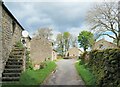
Arkleside
A Coverdale hamlet consisting of a scattering of cottages and farms. The place must have been here for centuries as it was recorded as 'Arkelsit' in 1240, whilst the origin of the name is reckoned to be from old Norse -Arkil+saetr [Arkil's seter, or summer pasture]
Image: © Gordon Hatton
Taken: 18 May 2021
0.06 miles
4
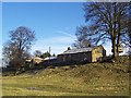
Arkleside
Hamlet in Coverdale dominated by the farm above
Image: © Chris Heaton
Taken: 31 Jan 2006
0.10 miles
5
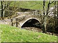
Arkleside Bridge
The bridge over the River Cover leading to Arkleside and the bridle path over the moor to Nidderdale.
Image: © Anthony Harrison
Taken: 6 Apr 2007
0.16 miles
6
The Cover at Arkleside Bridge
The stone arched bridge over the river gives access to the few buildings in the hamlet of Arkleside.
Image: © Gordon Hatton
Taken: 23 Feb 2020
0.17 miles
7
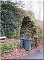
Old lime kiln by Arkleside Bridge
The lime kiln now appears to be a useful place to store refuse bins when awaiting collection by Richmondshire Council. An information board, which is part visible to the left, suggests that there are around 800 such kilns in the Yorkshire Dales, but I think this is a rather conservative figure.
Image: © Gordon Hatton
Taken: 23 Feb 2020
0.18 miles
8
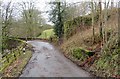
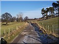
This way to Arkleside
The access road for the hamlet of Arkleside, which can be seen turning to the left to cross the Cover. On the right is what appears to be an old milk stand, now part covered in moss and vegetation [there was once a creamery further down the dale], and behind that is the side of the old lime kiln, also well covered in moss. Beyond Arkleside the tarmac ends and there is a rough track over the fell to Lodge and Scar House Reservoir in Nidderdale. This has always been a county road, but may now have been downgraded to a 'BOAT' [byway open to all traffic], and as far as I know it can still be used by responsible users in 4WD vehicles and scramble bikes.
Image: © Gordon Hatton
Taken: 23 Feb 2020
0.18 miles
9
Access Track near Arkleside
This must be newly constructed, as it is not marked on the Ordnance Survey Map
Image: © Chris Heaton
Taken: 22 Jan 2006
0.18 miles
10
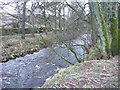
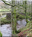
River Cover near Horsehouse, just downstream from Arkleside bridge
Arkleside bridge can just about be seen through the trees.
Image: © C P Smith
Taken: 25 Mar 2010
0.19 miles