IMAGES TAKEN NEAR TO
Coverham, Middleham, LEYBURN, DL8 4TG
Introduction
This page details the photographs taken nearby to DL8 4TG by members of the Geograph project.
The Geograph project started in 2005 with the aim of publishing, organising and preserving representative images for every square kilometre of Great Britain, Ireland and the Isle of Man.

There are currently over 7.5m images from over14,400 individuals and you can help contribute to the project by visiting https://www.geograph.org.uk
Image Map (Loading...)


Getting Data...Please wait
Leaflet Map data © OpenStreetMap
Images are licensed for reuse under creativecommons.org/licenses/by-sa/2.0
Notes
- Clicking on the map will re-center to the selected point.
- The higher the marker number, the further away the image location is from the centre of the postcode.
Image Listing (29 Images Found)
Images are licensed for reuse under creativecommons.org/licenses/by-sa/2.0
Image
Details
Distance
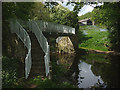
1
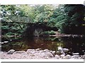
Bird Ridding Wath
This ford (wath) is found at the foot of Bird Ridding Lane beside Bird Ridding Farm on the River Cover.
http://youtu.be/cCT4WgeYaak
Image: © John Walton
Taken: 8 Feb 2015
0.06 miles
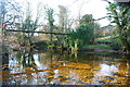
2
Footbridge at Bird Ridding Wath
Across the River Cover.
Image: © Karl and Ali
Taken: 18 May 2018
0.06 miles
3
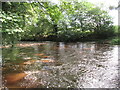
Bird Ridding Wath
Deep ford on the River Cover.
Image: © T Eyre
Taken: 12 Sep 2022
0.07 miles
4
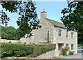
Coverham, Lane Cottage
There is a benchmark cut into the south-east face of the roadside cottage.
Image: © Mel Towler
Taken: 18 Jul 2022
0.07 miles
5
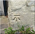
Coverham, Lane Cottage
The benchmark is cut into the south-east face of the roadside cottage.
Image: © Mel Towler
Taken: 18 Jul 2022
0.07 miles
8
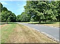
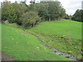
Coverham, Tup Gill Park
According to the OS benchmark database in this location, looking south to the Coverham/Middleham road there was a cutmark in a wall. The park is now a popular visitor attraction, the Forbidden Garden, and with lots of reshaping and redesigning of the grounds many walls have gone. The benchmark has been destroyed.
Image: © Mel Towler
Taken: 18 Jul 2022
0.11 miles
9
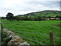
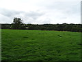
Wooded farmland in Coverdale
West of Bird Ridding Farm.
Image: © Christine Johnstone
Taken: 24 Sep 2016
0.12 miles