IMAGES TAKEN NEAR TO
Walden, LEYBURN, DL8 4LG
Introduction
This page details the photographs taken nearby to Walden, DL8 4LG by members of the Geograph project.
The Geograph project started in 2005 with the aim of publishing, organising and preserving representative images for every square kilometre of Great Britain, Ireland and the Isle of Man.

There are currently over 7.5m images from over14,400 individuals and you can help contribute to the project by visiting https://www.geograph.org.uk
Image Map
Images are licensed for reuse under creativecommons.org/licenses/by-sa/2.0
Notes
- Clicking on the map will re-center to the selected point.
- The higher the marker number, the further away the image location is from the centre of the postcode.
Image Listing (4 Images Found)
Images are licensed for reuse under creativecommons.org/licenses/by-sa/2.0
Image
Details
Distance
1
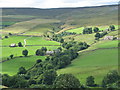
Looking West across the Walden Beck valley
This is near the head of the valley on the Eastern side after driving along a very minor road
Image: © Nick W
Taken: 7 Aug 2005
0.13 miles
2
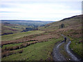
The bridleway to Coverdale
Looking back down Walden towards Wensleydale.
Image: © Karl and Ali
Taken: 23 Jan 2011
0.19 miles
3
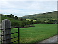
Looking north east down the valley of Walden Beck
This picture was taken from the point where the track to Cowstone Gill House and Harstone House leaves the road from West Burton.
Image: © C P Smith
Taken: 15 Jul 2010
0.23 miles
4
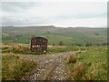
Descending the bridleway into Walden
The old goods wagon is reaching the end of its life as a shelter but it is probably over 100 years old
Image: © David Brown
Taken: 15 May 2021
0.25 miles