IMAGES TAKEN NEAR TO
West Burton, LEYBURN, DL8 4JP
Introduction
This page details the photographs taken nearby to DL8 4JP by members of the Geograph project.
The Geograph project started in 2005 with the aim of publishing, organising and preserving representative images for every square kilometre of Great Britain, Ireland and the Isle of Man.

There are currently over 7.5m images from over14,400 individuals and you can help contribute to the project by visiting https://www.geograph.org.uk
Image Map
Images are licensed for reuse under creativecommons.org/licenses/by-sa/2.0
Notes
- Clicking on the map will re-center to the selected point.
- The higher the marker number, the further away the image location is from the centre of the postcode.
Image Listing (157 Images Found)
Images are licensed for reuse under creativecommons.org/licenses/by-sa/2.0
Image
Details
Distance
1

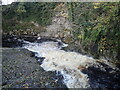
West Burton Mill
The former corn mill at West Burton stands high above Walden Beck, from which water was fed via a mill race leading from the plunge pool below Cauldron Force. The extension nearest the camera marks the former site of the water wheel.
Image: © Gordon Hatton
Taken: 21 Oct 2008
0.01 miles
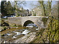
2
Walden Beck at West Burton
This is a little way below West Burton Falls and is seen from the footbridge across the stream.
Image: © Marathon
Taken: 26 Oct 2022
0.01 miles
3
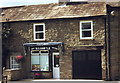
Butchers, West Burton, North Yorkshire
Image: © nick macneill
Taken: 20 Aug 1999
0.01 miles
4
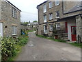
Lane in West Burton
This is where the riverside walk to West Burton Falls re-enters the village.
Image: © Marathon
Taken: 18 Aug 2023
0.01 miles
5
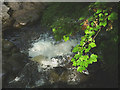
Walden Beck, West Burton
Sun on a sycamore branch below the footbridge which spans the beck.
Image: © Karl and Ali
Taken: 9 Aug 2015
0.01 miles
6
Bridge over Walden Beck, West Burton
Although there was snow in the fields and the sun was shining, I missed the peak of the snowmelt and Walden Beck was at quite a low level, making the bridge more photogenic than the waterfall just upstream.
Image: © Andy Waddington
Taken: 4 Apr 2013
0.02 miles
7
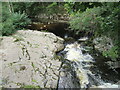
Walden Beck at West Burton
Looking downstream from the bridge.
Image: © T Eyre
Taken: 15 Sep 2022
0.02 miles
8
![A circular walk around West Burton [1]](https://s0.geograph.org.uk/geophotos/07/33/51/7335120_29af4ded_120x120.jpg)
A circular walk around West Burton [1]
Burton Bridge carries the footpath over Walden Beck.
The route crosses Walden Beck, passes through Barrack Wood, then ascends very steeply to the disused Hudson Quarry. Hudson Lane, Morpeth Lane and then High Lane are followed before descending towards Layrus. After passing the Preceptory of the Knights Templars, the footpath follows the contour to Morpeth Gate, Barrack Wood and back to the starting point at Burton Bridge. 4½ miles.
Image: © Michael Dibb
Taken: 26 Jun 2022
0.02 miles
9
![A circular walk around West Burton [2]](https://s1.geograph.org.uk/geophotos/07/33/51/7335121_d0bbf260_120x120.jpg)
A circular walk around West Burton [2]
Burton Bridge carries the footpath over Walden Beck.
The route crosses Walden Beck, passes through Barrack Wood, then ascends very steeply to the disused Hudson Quarry. Hudson Lane, Morpeth Lane and then High Lane are followed before descending towards Layrus. After passing the Preceptory of the Knights Templars, the footpath follows the contour to Morpeth Gate, Barrack Wood and back to the starting point at Burton Bridge. 4½ miles.
Image: © Michael Dibb
Taken: 26 Jun 2022
0.02 miles
10
![A circular walk around West Burton [3]](https://s3.geograph.org.uk/geophotos/07/33/51/7335123_4a41691f_120x120.jpg)
A circular walk around West Burton [3]
Burton Bridge carries the footpath over Walden Beck.
The route crosses Walden Beck, passes through Barrack Wood, then ascends very steeply to the disused Hudson Quarry. Hudson Lane, Morpeth Lane and then High Lane are followed before descending towards Layrus. After passing the Preceptory of the Knights Templars, the footpath follows the contour to Morpeth Gate, Barrack Wood and back to the starting point at Burton Bridge. 4½ miles.
Image: © Michael Dibb
Taken: 26 Jun 2022
0.02 miles