IMAGES TAKEN NEAR TO
Woodhall, LEYBURN, DL8 3LB
Introduction
This page details the photographs taken nearby to Woodhall, DL8 3LB by members of the Geograph project.
The Geograph project started in 2005 with the aim of publishing, organising and preserving representative images for every square kilometre of Great Britain, Ireland and the Isle of Man.

There are currently over 7.5m images from over14,400 individuals and you can help contribute to the project by visiting https://www.geograph.org.uk
Image Map
Images are licensed for reuse under creativecommons.org/licenses/by-sa/2.0
Notes
- Clicking on the map will re-center to the selected point.
- The higher the marker number, the further away the image location is from the centre of the postcode.
Image Listing (24 Images Found)
Images are licensed for reuse under creativecommons.org/licenses/by-sa/2.0
Image
Details
Distance
1
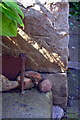
Benchmark on 'Arncliffe Farm'
Ordnance Survey cut mark benchmark described on the Bench Mark Database at http://www.bench-marks.org.uk/bm60019
Image: © Roger Templeman
Taken: 8 Sep 2014
0.01 miles
2
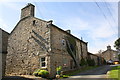
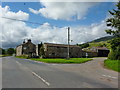
'Arncliffe Farm', Low Lane
There is an OS benchmark Image on the near corner of the house, left hand face
Image: © Roger Templeman
Taken: 8 Sep 2014
0.01 miles
3
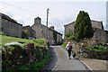
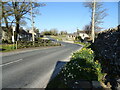
Low Lane, Woodhall
A quiet road in Woodhall leading to West End Farm
Image: © Julian Paren
Taken: 28 Apr 2019
0.03 miles
4
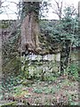
Rooted in limestone
Tree roots clinging precariously to a limestone outcrop near Woodhall.
Image: © James Allan
Taken: 15 Feb 2008
0.06 miles
5
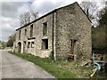
Barn Undergoing Conversion in Woodhall
Image: © David Robinson
Taken: 16 Apr 2022
0.08 miles
8
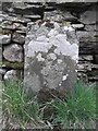
Old milestone
On the north side of the unclassified road north of the River Ure at Woodall between Carperby and Askrigg. There is a 16, the mileage to Richmond, inscribed near the top covered in white lichens which are indicative of the clean air. The stone may date from the 18C on the 1751 Lancaster to Richmond turnpike. One other remaining stone on this section of road is the same shape.
Image: © Chris Minto
Taken: 8 Apr 2019
0.10 miles
9

Old milestone near Woodhall
Shown as Richmond 16 Askrigg 2 on 1915 map.
Image: © Roger Templeman
Taken: 8 Sep 2014
0.10 miles
10
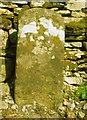
Old Milestone in Woodhall, Newbiggin Parish
Carved stone post by the UC road, in parish of NEWBIGGIN (RICHMONDSHIRE District), Woodhall between Carperby and Askrigg; West of houses, on verge back to drystone wall; by large gatepost 10m East of 'SLOW' on road and bends and junction signs, on North side of road. Richmond LH stone, erected by the Richmond & Lancaster (Eastern District) turnpike trust in the 18th century.
Inscription once read:-
(Richmond
(16)
(Askrigg
(2)
Milestone Society National ID: YN_LARC40.
Image: © C Minto
Taken: 8 Apr 2007
0.10 miles