IMAGES TAKEN NEAR TO
Charcoals Way, HAWES, DL8 3AU
Introduction
This page details the photographs taken nearby to Charcoals Way, DL8 3AU by members of the Geograph project.
The Geograph project started in 2005 with the aim of publishing, organising and preserving representative images for every square kilometre of Great Britain, Ireland and the Isle of Man.

There are currently over 7.5m images from over14,400 individuals and you can help contribute to the project by visiting https://www.geograph.org.uk
Image Map
Images are licensed for reuse under creativecommons.org/licenses/by-sa/2.0
Notes
- Clicking on the map will re-center to the selected point.
- The higher the marker number, the further away the image location is from the centre of the postcode.
Image Listing (372 Images Found)
Images are licensed for reuse under creativecommons.org/licenses/by-sa/2.0
Image
Details
Distance
1

Dales Countryside Museum Hawes
The former railway station and buildings have been purchased by the Yorkshire Dales National Park Authority and they are now converted into a museum. This most interesting museum tells the story of the people who have lived and worked in the Yorkshire Dales for more than 1000 years. There are many exhibits telling the story of lead mining and sheep farming. These railway carriages also have displays on show as you walk along inside the carriages. It’s well worth a visit especially on a rainy day.
Image: © Jennifer Petrie
Taken: 7 May 2019
0.03 miles
2

Hawes fire station
Hawes fire station, Hawes Industrial Estate, Brunt Acres Road, Hawes, North Yorkshire.
Image: © Kevin Hale
Taken: 3 Aug 2010
0.04 miles
3
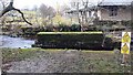
Remains of bridge which took railway over Gayle Beck west of Hawes Station
Image: © Roger Templeman
Taken: 19 Nov 2021
0.05 miles
5
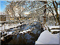
Railway trackbed, Hawes
This was the Midland Railway's branch to Hawes from Garsdale. There was once a through route from Northallerton to the Settle and Carlisle line. The eastern end of the line is now operated as a heritage railway and it is hoped one day to reopen the whole line.
Image: © Richard Webb
Taken: 16 Oct 2016
0.06 miles
6
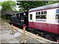
Wensleydale Railway
The Wensleydale Railway is a heritage railway operating 35 km of line between Northallerton and Redmire. The track has been lifted on the 29 km length of line westwards from Redmire via Hawes to Garsdale. The long term objective is to restore this section of the line as well. Meanwhile, this carriage adorns the Dales Countryside Museum.
Image: © Oliver Dixon
Taken: 9 Jun 2017
0.07 miles
7
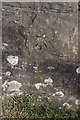
Benchmark on Brunt Acres Road railway bridge
Ordnance Survey cut mark benchmark described on the Bench Mark Database at http://www.bench-marks.org.uk/bm24336
Image: © Roger Templeman
Taken: 2 May 2013
0.07 miles
8
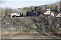
Eastern parapet of Brunt Acres Road railway bridge
There is an OS benchmark Image on a stone on the parapet in the middle of the image. Over the bridge is the former station (now a museum) and a steam engine and coaches on static display Image
Image: © Roger Templeman
Taken: 2 May 2013
0.07 miles
9
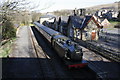
Hawes Museum, former station, from Brunt Acres Road bridge
An eastern region tank steam locomotive and coaches on static display on the trackbed of the dismantled line to Garsdale Station (formerly Hawes Junction)
Image: © Roger Templeman
Taken: 2 May 2013
0.07 miles
10
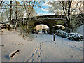
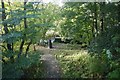
Bridge at the western end of Hawes Station
Bridge over the former railway track which was lifted after the line closed in 1964.
Image: © David Dixon
Taken: 28 Nov 2021
0.07 miles