IMAGES TAKEN NEAR TO
Firby, BEDALE, DL8 2PP
Introduction
This page details the photographs taken nearby to DL8 2PP by members of the Geograph project.
The Geograph project started in 2005 with the aim of publishing, organising and preserving representative images for every square kilometre of Great Britain, Ireland and the Isle of Man.

There are currently over 7.5m images from over14,400 individuals and you can help contribute to the project by visiting https://www.geograph.org.uk
Image Map
Images are licensed for reuse under creativecommons.org/licenses/by-sa/2.0
Notes
- Clicking on the map will re-center to the selected point.
- The higher the marker number, the further away the image location is from the centre of the postcode.
Image Listing (5 Images Found)
Images are licensed for reuse under creativecommons.org/licenses/by-sa/2.0
Image
Details
Distance
1
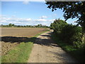
Access Track near Hollins House
This is a particularly long access track linking to the B6285 just south of Bedale
Image: © Chris Heaton
Taken: 26 Sep 2006
0.12 miles
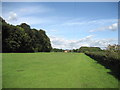
2
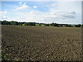
Looking over fields towards Firby
Countryside looking north west from near Hollins House
Image: © Chris Heaton
Taken: 26 Sep 2006
0.13 miles
3
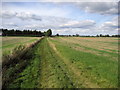
Track north of The Reeds
This track has just passed by the edge of a piece of woodland called The Reeds, and is heading towards Hollins House, hidden behind a line of conifer trees ahead
Image: © Chris Heaton
Taken: 26 Sep 2006
0.16 miles
4
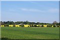
Farmland at Firby
A view across fields at Hollins Farm towards Firby House farm. The line of trees across the middle of the picture indicate the line of Firby Beck.
Image: © Gordon Hatton
Taken: 4 May 2011
0.16 miles
5
Approaching Hollins House
This is taken from the south west of Hollins House, while approaching this venerable establishment on the right of way from Snape
Image: © Chris Heaton
Taken: 26 Sep 2006
0.19 miles