IMAGES TAKEN NEAR TO
Burneston, BEDALE, DL8 2HX
Introduction
This page details the photographs taken nearby to DL8 2HX by members of the Geograph project.
The Geograph project started in 2005 with the aim of publishing, organising and preserving representative images for every square kilometre of Great Britain, Ireland and the Isle of Man.

There are currently over 7.5m images from over14,400 individuals and you can help contribute to the project by visiting https://www.geograph.org.uk
Image Map
Images are licensed for reuse under creativecommons.org/licenses/by-sa/2.0
Notes
- Clicking on the map will re-center to the selected point.
- The higher the marker number, the further away the image location is from the centre of the postcode.
Image Listing (95 Images Found)
Images are licensed for reuse under creativecommons.org/licenses/by-sa/2.0
Image
Details
Distance
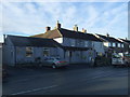
5
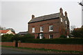
Lane House
Grade II listed building dating from mid 18th century
Image: © Graham Hogg
Taken: 31 Oct 2014
0.03 miles
6
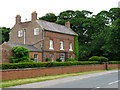
Lane House
Along Bedale Road in Burneston village.
Image: © David Rogers
Taken: 4 Jun 2009
0.03 miles
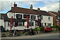
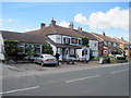
7
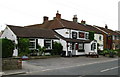
The Woodman Inn
Located on Bedale Road in the village of Burneston.
Image: © David Rogers
Taken: 4 Jun 2009
0.04 miles
8
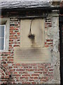
Sundial, Robinson Almshouses.
The sundial has a suitably serious text carved below.
Image: © Gordon Hatton
Taken: 7 Jun 2007
0.05 miles
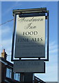
10
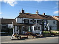
Woodman Inn, Burneston
Establishment that fulfils the refreshment requirements for the inhabitants of Burneston
Image: © Chris Heaton
Taken: 26 Sep 2006
0.05 miles