IMAGES TAKEN NEAR TO
Burneston Road, BEDALE, DL8 2HW
Introduction
This page details the photographs taken nearby to Burneston Road, DL8 2HW by members of the Geograph project.
The Geograph project started in 2005 with the aim of publishing, organising and preserving representative images for every square kilometre of Great Britain, Ireland and the Isle of Man.

There are currently over 7.5m images from over14,400 individuals and you can help contribute to the project by visiting https://www.geograph.org.uk
Image Map (Loading...)


Getting Data...Please wait
Leaflet Map data © OpenStreetMap
Images are licensed for reuse under creativecommons.org/licenses/by-sa/2.0
Notes
- Clicking on the map will re-center to the selected point.
- The higher the marker number, the further away the image location is from the centre of the postcode.
Image Listing (4 Images Found)
Images are licensed for reuse under creativecommons.org/licenses/by-sa/2.0
Image
Details
Distance
1
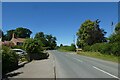
Road in Theakston
Looking along the road as it passes Theakston Hall.
Image: © DS Pugh
Taken: 10 Jul 2022
0.14 miles
2
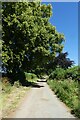
Theakston Hargill
Now a bridleway but once a public road.
Image: © DS Pugh
Taken: 10 Jul 2022
0.15 miles
3
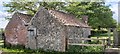
Pumphouse on Theakston Hargill
The stone building has a benchmark on this (its eastern) face, next to the north corner.
Image: © Matthew Hatton
Taken: 8 May 2020
0.16 miles
4
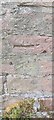
Poorly Defined Benchmark
This mark is barely visible due to later rendering obscuring the arrows. Height is measured at 138.8ft asl.
Image: © Matthew Hatton
Taken: 8 May 2020
0.16 miles