IMAGES TAKEN NEAR TO
Exelby Road, BEDALE, DL8 2EX
Introduction
This page details the photographs taken nearby to Exelby Road, DL8 2EX by members of the Geograph project.
The Geograph project started in 2005 with the aim of publishing, organising and preserving representative images for every square kilometre of Great Britain, Ireland and the Isle of Man.

There are currently over 7.5m images from over14,400 individuals and you can help contribute to the project by visiting https://www.geograph.org.uk
Image Map
Images are licensed for reuse under creativecommons.org/licenses/by-sa/2.0
Notes
- Clicking on the map will re-center to the selected point.
- The higher the marker number, the further away the image location is from the centre of the postcode.
Image Listing (2 Images Found)
Images are licensed for reuse under creativecommons.org/licenses/by-sa/2.0
Image
Details
Distance
1
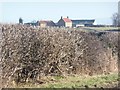
The middle Bromaking Grange
One of three with this name just north of Exelby. Taken from the B6285.
Image: © Christine Johnstone
Taken: 1 Feb 2011
0.04 miles
2
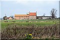
Towards Bromakin Grange
A view towards the farm of Bromakin Grange which is in the NE corner of the grid square. Odd that the OS map shows another farm with the same name in the same square.
Image: © Gordon Hatton
Taken: 30 Mar 2018
0.25 miles