IMAGES TAKEN NEAR TO
Station Road, BEDALE, DL8 1SY
Introduction
This page details the photographs taken nearby to Station Road, DL8 1SY by members of the Geograph project.
The Geograph project started in 2005 with the aim of publishing, organising and preserving representative images for every square kilometre of Great Britain, Ireland and the Isle of Man.

There are currently over 7.5m images from over14,400 individuals and you can help contribute to the project by visiting https://www.geograph.org.uk
Image Map
Images are licensed for reuse under creativecommons.org/licenses/by-sa/2.0
Notes
- Clicking on the map will re-center to the selected point.
- The higher the marker number, the further away the image location is from the centre of the postcode.
Image Listing (20 Images Found)
Images are licensed for reuse under creativecommons.org/licenses/by-sa/2.0
Image
Details
Distance
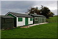
1
Play Area behind Newton-le-Willows Village Hall
Image: © David Dixon
Taken: 5 Jul 2022
0.09 miles
2
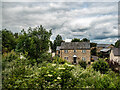
Cottage in Newton-le-Willows
Viewed from a Wensleydale Railway train.
Image: © John Lucas
Taken: 11 Jun 2024
0.09 miles
3
Site of Jervaulx station, Newton-le-Willows 2000
View SW: the station had been on the right by the bridge ahead, which carries the ex-NER Wensleydale Railway, Northallerton (left) - (right) Hawes and Garsdale. This was closed 26/4/54, although remaining open to Redmire for excursions and for various irregular freight flows until about 1990. In 2003 the heritage Wensleydale Railway plc leased the Northallerton - Redmire section from Railtrack and has gradually restored and reopened the line and stations westwards from their (separate) Northallerton West.
Image: © Ben Brooksbank
Taken: 1 Jul 2000
0.13 miles
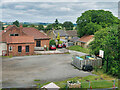
4
Newton-le-Willows Cricket Pavilion
Structures located on the south eastern edge of the cricket pitch, Newton-le-Willows near Bedale.
The club play in the Nidderdale and District League, Division 7 at the time of my visit.
There is a public footpath that runs straight across the cricket square, which could be inconvenient on matchdays.
Image: © Chris Heaton
Taken: 7 Oct 2017
0.14 miles
5
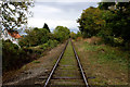
The Wensleydale Railway at Newton-le-Willows
Section of the 22 mile heritage railway line between Northallerton West and Redmire in Wensleydale
Image: © Chris Heaton
Taken: 7 Oct 2017
0.14 miles
7
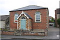
Former Methodist Chapel
There is an OS benchmark Image on the front of this converted chapel on the stone course about 3 feet from the right hand corner
Image: © Roger Templeman
Taken: 21 Sep 2014
0.16 miles
8
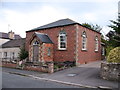
Methodist chapel, Newton le Willows
This building would now appear to be the former Methodist chapel as there is evidence of recent work to convert it into a dwelling.
Image: © Gordon Hatton
Taken: 4 Sep 2011
0.16 miles
9
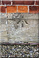
Benchmark on former Methodist Chapel
Ordnance Survey pivot benchmark described on the Bench Mark Database at http://www.bench-marks.org.uk/bm60445
Image: © Roger Templeman
Taken: 21 Sep 2014
0.16 miles
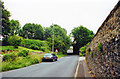
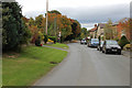
10
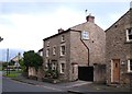
Village houses, Newton le Willows
Traditional houses in the village with stone construction and slate roofs.
Image: © Gordon Hatton
Taken: 4 Sep 2011
0.19 miles