IMAGES TAKEN NEAR TO
Little Crakehall, BEDALE, DL8 1LA
Introduction
This page details the photographs taken nearby to DL8 1LA by members of the Geograph project.
The Geograph project started in 2005 with the aim of publishing, organising and preserving representative images for every square kilometre of Great Britain, Ireland and the Isle of Man.

There are currently over 7.5m images from over14,400 individuals and you can help contribute to the project by visiting https://www.geograph.org.uk
Image Map
Images are licensed for reuse under creativecommons.org/licenses/by-sa/2.0
Notes
- Clicking on the map will re-center to the selected point.
- The higher the marker number, the further away the image location is from the centre of the postcode.
Image Listing (7 Images Found)
Images are licensed for reuse under creativecommons.org/licenses/by-sa/2.0
Image
Details
Distance
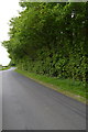
1
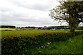
Hunters Hill Farm
Industrial scale agriculture.
Image: © Tony Simms
Taken: 27 May 2015
0.03 miles
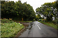
2
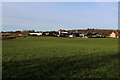
Approaching Hunter's Hill Farm
The public footpath runs diagonally across this field towards the buildings that make up Hunter's Hill Farm.
The farmer, however, earned my displeasure by enclosing said field with an electric fence - ignoring the presence of a right of way. Care was needed to avoid several volts of electricity passing through my body while negotiating entry and exit from this pasture.
Image: © Chris Heaton
Taken: 18 Dec 2017
0.05 miles
3
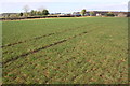
View from footpath to Langthorne towards Hunter's Hill Farm
Image: © Roger Templeman
Taken: 25 Feb 2018
0.07 miles
4
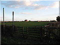
Footpath to Hunter's Hill Farm
Path across pastureland in Crakehall parish.
Image: © Gordon Hatton
Taken: 5 Feb 2007
0.12 miles
7
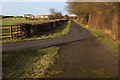
Access Lane to Mill Close Farm
Passing beside Waste Wood
Image: © Chris Heaton
Taken: 18 Dec 2017
0.20 miles