IMAGES TAKEN NEAR TO
Millfield Close, NORTHALLERTON, DL7 9SF
Introduction
This page details the photographs taken nearby to Millfield Close, DL7 9SF by members of the Geograph project.
The Geograph project started in 2005 with the aim of publishing, organising and preserving representative images for every square kilometre of Great Britain, Ireland and the Isle of Man.

There are currently over 7.5m images from over14,400 individuals and you can help contribute to the project by visiting https://www.geograph.org.uk
Image Map
Images are licensed for reuse under creativecommons.org/licenses/by-sa/2.0
Notes
- Clicking on the map will re-center to the selected point.
- The higher the marker number, the further away the image location is from the centre of the postcode.
Image Listing (34 Images Found)
Images are licensed for reuse under creativecommons.org/licenses/by-sa/2.0
Image
Details
Distance
1
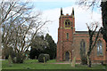
St. John the Baptist Church, Leeming
Red brick church in the small village of Leeming, next to the RAF airbase.
Image: © Chris Heaton
Taken: 21 Mar 2016
0.04 miles
2
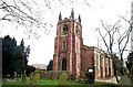
Leeming, Church of St John The Baptist
This Church is just to the south west of centre of the O/S grid it occupies
Image: © Bill Henderson
Taken: Unknown
0.06 miles
3
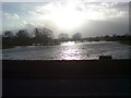
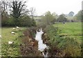
Bedale Beck looking West after the floods on 11 Jan 2007
The torrential rain that fell in and around the area, on the day before this picture was taken, caused the humble beck to resemble the Mississippi Delta!
Image: © Frank Glover
Taken: 11 Jan 2007
0.13 miles
4
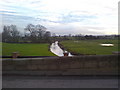
Bedale Beck looking West
Bedale Beck is a physical boundary between the villages of Leeming and Leeming Bar. The beck runs roughly west to east through the grid square, becoming a tributary of the River Swale on the eastern side of RAF Leeming.
Image: © Frank Glover
Taken: 16 Jan 2007
0.13 miles
5
Bedale Beck from Leeming Bridge
A glance at the OS map will show that Bedale Beck follows a course that appears to be a series of straight lines with occasional bends between Bedale and the Swale. This could be as a result of works to improve drainage, but I'm inclined to think that any straightening was done as part of the failed scheme to canalise the beck in the 18thC. The remains of a lock a short way upstream from here and the more obvious 'harbour' works in Bedale help confirm my suspicions.
Image: © Gordon Hatton
Taken: 6 Nov 2018
0.14 miles
6
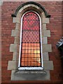
Leeming Methodist Church
Leeming Methodist Church Stained Glass Window, featuring carved stone details. 19th century.
Image: © Miles
Taken: 5 Sep 2022
0.15 miles
7
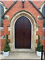
Leeming Methodist Church
Leeming Methodist Church, entrance doors featuring carved stone details and stained glass windows. Neo-Gothic style.
Image: © Miles
Taken: 28 Nov 2022
0.15 miles
9
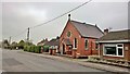
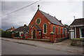
Leeming Methodist chapel, Leeming
On Ronan Road. Originally Wesleyan Methodist
Image: © Chris Morgan
Taken: 31 Oct 2015
0.15 miles
10
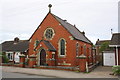
Leeming Methodist Church, Roman Road
There is an OS benchmark Image on the side of the church at the near corner
Image: © Roger Templeman
Taken: 16 Jun 2013
0.15 miles