IMAGES TAKEN NEAR TO
Leeming Lane, NORTHALLERTON, DL7 9RS
Introduction
This page details the photographs taken nearby to Leeming Lane, DL7 9RS by members of the Geograph project.
The Geograph project started in 2005 with the aim of publishing, organising and preserving representative images for every square kilometre of Great Britain, Ireland and the Isle of Man.

There are currently over 7.5m images from over14,400 individuals and you can help contribute to the project by visiting https://www.geograph.org.uk
Image Map
Images are licensed for reuse under creativecommons.org/licenses/by-sa/2.0
Notes
- Clicking on the map will re-center to the selected point.
- The higher the marker number, the further away the image location is from the centre of the postcode.
Image Listing (17 Images Found)
Images are licensed for reuse under creativecommons.org/licenses/by-sa/2.0
Image
Details
Distance
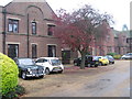
1
Benchmark on police house
Ordnance Survey cut mark benchmark described on the Bench Mark Database at http://www.bench-marks.org.uk/bm49208
Image: © Roger Templeman
Taken: 16 Jun 2013
0.02 miles
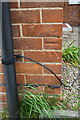
2
Police House, Leeming Lane
There is an OS benchmark Image on the near corner to the right of the black downpipe
Image: © Roger Templeman
Taken: 16 Jun 2013
0.03 miles
3
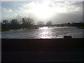
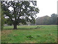
Bedale Beck looking West
Bedale Beck is a physical boundary between the villages of Leeming and Leeming Bar. The beck runs roughly west to east through the grid square, becoming a tributary of the River Swale on the eastern side of RAF Leeming.
Image: © Frank Glover
Taken: 16 Jan 2007
0.11 miles
4
Bedale Beck looking West after the floods on 11 Jan 2007
The torrential rain that fell in and around the area, on the day before this picture was taken, caused the humble beck to resemble the Mississippi Delta!
Image: © Frank Glover
Taken: 11 Jan 2007
0.11 miles
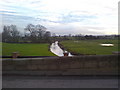
5
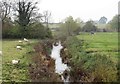
Bedale Beck from Leeming Bridge
A glance at the OS map will show that Bedale Beck follows a course that appears to be a series of straight lines with occasional bends between Bedale and the Swale. This could be as a result of works to improve drainage, but I'm inclined to think that any straightening was done as part of the failed scheme to canalise the beck in the 18thC. The remains of a lock a short way upstream from here and the more obvious 'harbour' works in Bedale help confirm my suspicions.
Image: © Gordon Hatton
Taken: 6 Nov 2018
0.11 miles
6
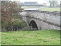
Leeming Bridge
Sturdy 18thC bridge over Bedale Beck at Leeming. The bridge once carried the A1 over the beck, but over the decades the line of the main road to the north has changed twice, and this has become a quiet backwater.
Image: © Gordon Hatton
Taken: 6 Nov 2018
0.13 miles
7
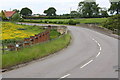
Leeming Bridge, Leeming Lane
The bridge, dated 1913, takes the road over Bedale Beck. There is an OS benchmark Image on the right hand side parapet near its junction with the wooden fence
Image: © Roger Templeman
Taken: 16 Jun 2013
0.13 miles
9
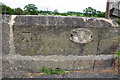
Benchmark on Leeming Bridge
Ordnance Survey cut mark benchmark described on the Bench Mark Database at http://www.bench-marks.org.uk/bm49293
Image: © Roger Templeman
Taken: 16 Jun 2013
0.15 miles