IMAGES TAKEN NEAR TO
South Otterington, NORTHALLERTON, DL7 9HE
Introduction
This page details the photographs taken nearby to DL7 9HE by members of the Geograph project.
The Geograph project started in 2005 with the aim of publishing, organising and preserving representative images for every square kilometre of Great Britain, Ireland and the Isle of Man.

There are currently over 7.5m images from over14,400 individuals and you can help contribute to the project by visiting https://www.geograph.org.uk
Image Map
Images are licensed for reuse under creativecommons.org/licenses/by-sa/2.0
Notes
- Clicking on the map will re-center to the selected point.
- The higher the marker number, the further away the image location is from the centre of the postcode.
Image Listing (37 Images Found)
Images are licensed for reuse under creativecommons.org/licenses/by-sa/2.0
Image
Details
Distance
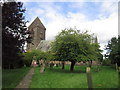
1
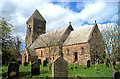
South Otterington, St Andrew's Church
This Church is central in the western quarter of the O/S grid it occupies.
Image: © Bill Henderson
Taken: Unknown
0.03 miles
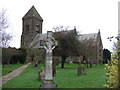
3
St Andrews Parish Church
Rebuilt in 1846 on the site of a late Norman structure.
Image: © David Rogers
Taken: 11 Jan 2010
0.04 miles
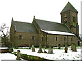
4
St Andrew's church, South Otterington
Built in the 1840's in a neo Norman style. A rather heavy design in dark sandstone with an odd little pyramid roof on the tower.
Image: © Gordon Hatton
Taken: 25 Sep 2008
0.04 miles
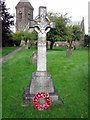
7
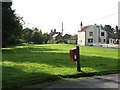
The Green, Little Otterington
South Otterington is a village with an odd layout. The main development is along the A167, but parallel to that is another 'main street' which is also a cul de sac. This area is known locally as 'Little Otterington'.
Image: © Gordon Hatton
Taken: 25 Sep 2008
0.06 miles
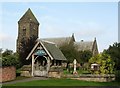
8
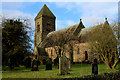
St. Andrew's Church, South Otterington
Rather unattractive Early Victorian Church, catering to the ecclesiastical needs of South Otterington.
Image: © Chris Heaton
Taken: 1 Jan 2018
0.06 miles
9

South Otterington School
A C of E primary school serving South Otterington, Newby Wiske and surrounding area. The attractive building dates from the early nineties.
Image: © Gordon Hatton
Taken: 25 Sep 2008
0.07 miles
10
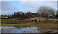
Otterington Bridge
Carries the road over the River Wiske between South Otterington and Newby Wiske
Image: © Chris Heaton
Taken: 1 Jan 2018
0.09 miles