IMAGES TAKEN NEAR TO
Conygarth Way, Leeming Bar Business Park, NORTHALLERTON, DL7 9FD
Introduction
This page details the photographs taken nearby to Conygarth Way, Leeming Bar Business Park, DL7 9FD by members of the Geograph project.
The Geograph project started in 2005 with the aim of publishing, organising and preserving representative images for every square kilometre of Great Britain, Ireland and the Isle of Man.

There are currently over 7.5m images from over14,400 individuals and you can help contribute to the project by visiting https://www.geograph.org.uk
Image Map
Images are licensed for reuse under creativecommons.org/licenses/by-sa/2.0
Notes
- Clicking on the map will re-center to the selected point.
- The higher the marker number, the further away the image location is from the centre of the postcode.
Image Listing (23 Images Found)
Images are licensed for reuse under creativecommons.org/licenses/by-sa/2.0
Image
Details
Distance
1
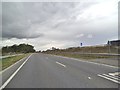
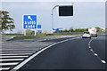
A6055 View
The view alongside the A1(M) motorway near junction 51 at Leeming Bar, North Yorkshire.
Image: © Gordon Griffiths
Taken: 14 Aug 2014
0.07 miles
2
Aiskew and Leeming Bar : A1(M)
At Leemington Bar Junction of the A1(M).
Image: © Lewis Clarke
Taken: 21 Sep 2020
0.12 miles
4
Aiskew Grange, Back Lane
'Aiskew Equine & Pet Supplies'
Image: © Roger Templeman
Taken: 29 Aug 2016
0.14 miles
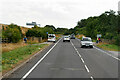
5
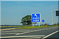
A1(M) northbound at Leeming Bar
The Leeming Interchange is junction 51 of the A1(M).
This junction was built to serve the new A684 Leeming Bar bypass. it acted as a northern temporary terminus of the A1(M) for a few years, until late 2016 when the Leeming to Barton improvements opened (https://www.sabre-roads.org.uk/wiki/index.php?title=Leeming_Interchange SABRE).
Image: © David Dixon
Taken: 29 Apr 2019
0.14 miles
6
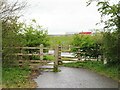
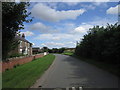
The end of Back Lane
The eastern end of Back Lane out of Aiskew is now a dead end except for cyclists and pedestrians, as this is part of national Cycle Route 71. Beyond the barrier is the A6055 and beyond that at the top of the bank is the A1(M). Did Back Lane ever connect with A1? It seems not, at least not for a very long time, as during the A1's last incarnation as a dual carriageway the lane followed much the same course as the current A6055 passing the present roundabout a short distance north and then onwards for another 400m before crossing the A1 by a bridge to eventually reach the Leases Road on the east side. Long before the A1 dual carriageway was constructed, Leases Road was the old single carriageway A1 which passed through the middle of Leeming Bar village.
Image: © Gordon Hatton
Taken: 29 Apr 2021
0.18 miles
7
Back Lane at the A6055
With the A1M in the background.
Image: © Ian S
Taken: 26 Aug 2012
0.18 miles
9
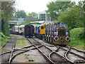
The sidings west of Leeming Bar Station
Ten years earlier the stock was all passenger Image
Image: © Christine Johnstone
Taken: 15 May 2015
0.20 miles
10
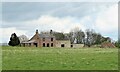
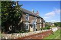
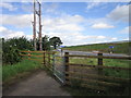
Micklebrack, off Back Lane
Difficult to assess what is going on with this set of buildings. Micklebrack is certainly a farmhouse that has been around for some time as it is shown on first edition six inch maps, so is this the original farmhouse undergoing some sort of reconstruction? Magnifying the image shows interior thermal block walls, so one assumes that this is the case.
Image: © Gordon Hatton
Taken: 29 Apr 2021
0.21 miles