IMAGES TAKEN NEAR TO
Spring Terrace, NORTHALLERTON, DL7 8UP
Introduction
This page details the photographs taken nearby to Spring Terrace, DL7 8UP by members of the Geograph project.
The Geograph project started in 2005 with the aim of publishing, organising and preserving representative images for every square kilometre of Great Britain, Ireland and the Isle of Man.

There are currently over 7.5m images from over14,400 individuals and you can help contribute to the project by visiting https://www.geograph.org.uk
Image Map
Images are licensed for reuse under creativecommons.org/licenses/by-sa/2.0
Notes
- Clicking on the map will re-center to the selected point.
- The higher the marker number, the further away the image location is from the centre of the postcode.
Image Listing (40 Images Found)
Images are licensed for reuse under creativecommons.org/licenses/by-sa/2.0
Image
Details
Distance
1

Northallerton: a Down freight heading for Tees-side
View SW, on the upper line towards Northallerton station and the ex-North Eastern ECML to York and the South. This Class F freight is headed (perhaps unusually) by an A1 Pacific (No. 60153 'Flamboyant') has come off the main line from York, which is seen above heading for Darlington, on the Low Level avoiding-line and is heading for Eaglescliffe and probably Newport Yard, Thornaby. An enormous amount of freight traffic ran through Northallerton to Tees-side as well as along the ECML, making Northallerton one of the busiest junctions in the whole country.
Image: © Ben Brooksbank
Taken: 19 Apr 1961
0.02 miles
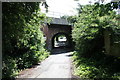
2

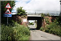
Main line railway bridge
Carrying the main London to Edinburgh east-coast railway line over Springwell Lane.
This section of the line connecting York to Darlington was opened in 1841.
I presume this lovely skew bridge dates from then.
When electrification came in additional work was done to the bridge as can be seen by the concrete on top.
Image: © Bob Embleton
Taken: 2 Jul 2010
0.04 miles
3
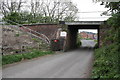
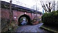
Under, over, under
Springwell Lane crosses three railway lines in a couple of hundred metres.
First it goes under the descending line from Northallerton station (to the left) to Teeside.
It then goes over the unmanned level crossing taking the low level goods line to Teeside avoiding the station.
In the distance beyond the cars is the bridge taking the electrified London to Edinburgh high level line.
Image: © Bob Embleton
Taken: 2 Jul 2010
0.05 miles
4
Railway Bridge LEN 2-3, Springwell Lane
There is an OS benchmark Image on the left hand side of the bridge at the junction of the bridge wall and the steps providing trackside access from the lane.
Image: © Roger Templeman
Taken: 20 May 2012
0.05 miles
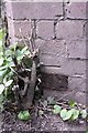
5
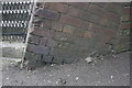
Benchmark on Springwell Lane railway bridge
Ordnance Survey cut mark benchmark described on the Bench Mark Database at http://www.bench-marks.org.uk/bm32850
Image: © Roger Templeman
Taken: 20 May 2012
0.05 miles
6
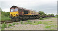
EWS-liveried locomotive hauling empty steel carrier wagons south
The train headed by Class 66 number 66089 is on freight line bypassing Northallerton station
Image: © Luke Shaw
Taken: 2 Jun 2019
0.05 miles
7
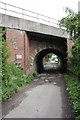
Main line railway bridge
Over Springwell Lane.
The skew bridge is possibly original, dating back to the 1840s, but was heavily modified when the east coast main line was electrified in the late 1980s.
New brick supports have been added to this side of the bridge and the large grey concrete slab laid.
Image: © Bob Embleton
Taken: 2 Jul 2010
0.05 miles
8
Railway Bridge over Springwell Lane
This bridge was built in 1846-7 by the Great North of England Railway Co. It carries the main East Coast Line from London Kings Cross to Edinburgh Waverley.
Springwell Lane is little more than an unmade access road to the small number of houses along here, and is riddled with pot-holes.
The concrete top was added when the line was widened in the 1960's. It was electrified in 1990.
Image: © Matthew Hatton
Taken: 13 Dec 2015
0.06 miles
9
Railway Bridge ECM 5/63, Springwell Lane
The bridge carries the East Coast Main Line over Springwell Lane. There is an OS benchmark Image on the inside wall of the bridge on the left hand side of the lane
Image: © Roger Templeman
Taken: 20 May 2012
0.06 miles
10
Benchmark on Castle Hills railway bridge
Ordnance Survey cut mark benchmark described on the Bench Mark Database at http://www.bench-marks.org.uk/bm32848
Image: © Roger Templeman
Taken: 20 May 2012
0.06 miles