IMAGES TAKEN NEAR TO
Bailey Court, NORTHALLERTON, DL7 8PR
Introduction
This page details the photographs taken nearby to Bailey Court, DL7 8PR by members of the Geograph project.
The Geograph project started in 2005 with the aim of publishing, organising and preserving representative images for every square kilometre of Great Britain, Ireland and the Isle of Man.

There are currently over 7.5m images from over14,400 individuals and you can help contribute to the project by visiting https://www.geograph.org.uk
Image Map
Images are licensed for reuse under creativecommons.org/licenses/by-sa/2.0
Notes
- Clicking on the map will re-center to the selected point.
- The higher the marker number, the further away the image location is from the centre of the postcode.
Image Listing (67 Images Found)
Images are licensed for reuse under creativecommons.org/licenses/by-sa/2.0
Image
Details
Distance
1
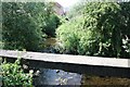
The Willow Beck
Looking downstream as the beck follows the industrial area of Springwell Lane.
The concrete protects pipes over the stream and an important place to fish for minnows and sticklebacks as well as aerial bombardment of enemy twigs.
Here I would carry out many civil engineering projects in my early years - despite rubbish (including a broken vacuum flask) being tossed over the wall from the workers next door.
It now looks very overgrown and unplayed in.
Image: © Bob Embleton
Taken: 2 Jul 2010
0.06 miles
2
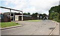
Springwell Lane, Northallerton
This used to be a mainly industrial area of town though many old firms have closed and housing developments taken over.
The Archers Removal firm is 90 years old.
Taken from the bridge over the Willow Beck.
Image: © Bob Embleton
Taken: 2 Jul 2010
0.08 miles
3
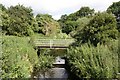
Willow Beck
Taken from the Springwell Lane bridge.
Close to its confluence with the Sun Beck which runs under the town centre.
The meadow land appears to be unused now, but used to have cows grazing here in my childhood (1950s and 1960s).
This was one of my favourite play areas.
I once saw a water vole cross the beck.
Image: © Bob Embleton
Taken: 2 Jul 2010
0.08 miles
4
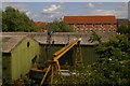
Engineering works, Northallerton, from the railway
Image: © Christopher Hilton
Taken: 12 Jul 2015
0.09 miles
6
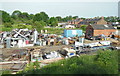
Railway Bridge LEN 2-3, Springwell Lane
There is an OS benchmark Image on the left hand side of the bridge at the junction of the bridge wall and the steps providing trackside access from the lane.
Image: © Roger Templeman
Taken: 20 May 2012
0.10 miles
7
Benchmark on Springwell Lane railway bridge
Ordnance Survey cut mark benchmark described on the Bench Mark Database at http://www.bench-marks.org.uk/bm32850
Image: © Roger Templeman
Taken: 20 May 2012
0.10 miles
8
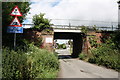
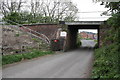
Under, over, under
Springwell Lane crosses three railway lines in a couple of hundred metres.
First it goes under the descending line from Northallerton station (to the left) to Teeside.
It then goes over the unmanned level crossing taking the low level goods line to Teeside avoiding the station.
In the distance beyond the cars is the bridge taking the electrified London to Edinburgh high level line.
Image: © Bob Embleton
Taken: 2 Jul 2010
0.10 miles
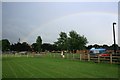
10
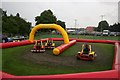
Applegarth School Playing Fields
The school fete and the rain doesn't the spirits of these aspiring Lewis Hamiltons.
Image: © Mick Garratt
Taken: 5 Jul 2007
0.12 miles