IMAGES TAKEN NEAR TO
The Fairway, NORTHALLERTON, DL7 8BB
Introduction
This page details the photographs taken nearby to The Fairway, DL7 8BB by members of the Geograph project.
The Geograph project started in 2005 with the aim of publishing, organising and preserving representative images for every square kilometre of Great Britain, Ireland and the Isle of Man.

There are currently over 7.5m images from over14,400 individuals and you can help contribute to the project by visiting https://www.geograph.org.uk
Image Map
Images are licensed for reuse under creativecommons.org/licenses/by-sa/2.0
Notes
- Clicking on the map will re-center to the selected point.
- The higher the marker number, the further away the image location is from the centre of the postcode.
Image Listing (127 Images Found)
Images are licensed for reuse under creativecommons.org/licenses/by-sa/2.0
Image
Details
Distance
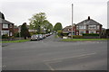
1
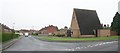
Romanby Methodist Church, The Fairway
The Fairway is a link road (rat run) between Boroughbridge Road and Harewood Lane. Plenty of signs indicating the speed limit.
Image: © Bob Embleton
Taken: 19 Jun 2007
0.04 miles
2
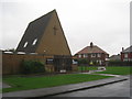
Romanby Methodist church
An A frame style popular with the Methodist church in the 1960s, see Image and Image for another example.
Image: © Jonathan Thacker
Taken: 26 Nov 2012
0.06 miles
3
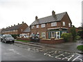
Shop and housing, The Fairway, Romanby
Typical 1950s/60s estate.
Image: © Jonathan Thacker
Taken: 26 Nov 2012
0.08 miles
4
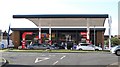
New filling station on Boroughbridge Road
This filling station and convenience store opened in the summer of 2018 and replaced a former tyre depot on the same site. A useful addition for motorists as the town's other two filling stations are both on the northern fringe of the town on the far side of traffic queues.
Image: © Gordon Hatton
Taken: 26 Sep 2018
0.09 miles
5
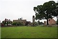
Romanby War Memorial
At the junction of Harewood Lane and Ainderby Road with its own small triangle of parkland. With St. James' C of E Church behind.
Image
Image
Image
Image
Image: © Bob Embleton
Taken: 19 Jun 2007
0.10 miles
6
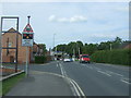
Approaching the level crossing on Boroughbridge Road, Northallerton
Looking north east.
Image: © JThomas
Taken: 1 Jun 2017
0.10 miles
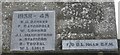
7
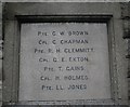
Romanby War Memorial Plaque (West Face)
Names in alphabetical order of those fallen in World War I.
Image: © Bob Embleton
Taken: 19 Jun 2007
0.10 miles
8
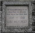
Romanby War Memorial Plaque (North Face)
World War I memorial.
Image: © Bob Embleton
Taken: 19 Jun 2007
0.11 miles
9
View down Farndale Avenue
View across Boroughbridge Road.
Image: © Roger Templeman
Taken: 20 May 2012
0.11 miles
10
Romanby War Memorial Plaque for WWII on the North Face
Set above the Front face of the WWI memorial plaque.
Image: © Bob Embleton
Taken: 19 Jun 2007
0.11 miles