IMAGES TAKEN NEAR TO
DL7 7AU
Introduction
This page details the photographs taken nearby to DL7 7AU by members of the Geograph project.
The Geograph project started in 2005 with the aim of publishing, organising and preserving representative images for every square kilometre of Great Britain, Ireland and the Isle of Man.

There are currently over 7.5m images from over14,400 individuals and you can help contribute to the project by visiting https://www.geograph.org.uk
Image Map
Images are licensed for reuse under creativecommons.org/licenses/by-sa/2.0
Notes
- Clicking on the map will re-center to the selected point.
- The higher the marker number, the further away the image location is from the centre of the postcode.
Image Listing (160 Images Found)
Images are licensed for reuse under creativecommons.org/licenses/by-sa/2.0
Image
Details
Distance
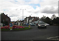
1
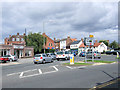
Northallerton - Roundabout at High Street (southern end)
The roundabout at the end of South Parade with High Street to the left, East Road ahead, and Thirsk Road to the right (out of picture).
Image: © David Ward
Taken: 27 Jul 2007
0.03 miles
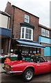
2
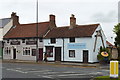
The Nags Head & Alexander Optometrists, Northallerton
A couple of quite ancient buildings, nicely restored and presented, at the south end of Northallerton High Street
Image: © Tony Simms
Taken: 6 May 2015
0.03 miles
3
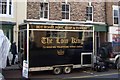
The Loin King at Northallerton
Good pun ... and Good Pork on a Good Bun
Image: © Terry Robinson
Taken: 8 Oct 2008
0.04 miles
4
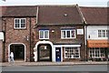
Entrance Arch to New Row, High Street
New Row was a muddy cobbled street lined on both sides with terraced houses in poor condition. They were demolished in the 1960s, but the public footpath still provides an east west route across the town. Notice how the Argos shop to the left has been built to give an old feel and reflect the archway in its entrance lobby.
Image: © Bob Embleton
Taken: 18 Jun 2007
0.04 miles
6
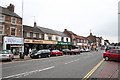
East Side of the Southern End of The High Street
The wide High Street provides ample space for free short-term parking (controlled by free discs available in most shops). Good to see some family businesses still going. In the late 1950s my brother and I saved up our pocket money to buy a valve* from Maxwell's to repair our radiogram. A start to a career in electronics! (*tube to our U.S. cousins.)
Image: © Bob Embleton
Taken: 18 Jun 2007
0.06 miles
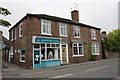
7
Greengrocer's, Northallerton High Street
Image: © Alpin Stewart
Taken: 9 Sep 2016
0.06 miles
8
Yorkshire Cancer Research, #32 Romanby Road
Image: © Roger Templeman
Taken: 20 May 2012
0.06 miles
9
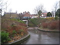
Subway under East Road
Not surprisingly on a day when many of Northallerton's roads were flooded, this underpass requires the use of wellington boots.
Image: © Jonathan Thacker
Taken: 26 Nov 2012
0.06 miles
10
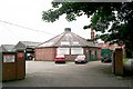
Northallerton Cattle Mart
The octagonal building was used for the auctions of cattle who were paraded around in the centre whilst the farmers and or butchers lined the walls on raised platforms bidding. Sometimes lucky children got to parade the animals around in the early 1960s :-).
Image: © Bob Embleton
Taken: 18 Jun 2007
0.08 miles