IMAGES TAKEN NEAR TO
John Hoares Place, NORTHALLERTON, DL7 0RE
Introduction
This page details the photographs taken nearby to John Hoares Place, DL7 0RE by members of the Geograph project.
The Geograph project started in 2005 with the aim of publishing, organising and preserving representative images for every square kilometre of Great Britain, Ireland and the Isle of Man.

There are currently over 7.5m images from over14,400 individuals and you can help contribute to the project by visiting https://www.geograph.org.uk
Image Map
Images are licensed for reuse under creativecommons.org/licenses/by-sa/2.0
Notes
- Clicking on the map will re-center to the selected point.
- The higher the marker number, the further away the image location is from the centre of the postcode.
Image Listing (36 Images Found)
Images are licensed for reuse under creativecommons.org/licenses/by-sa/2.0
Image
Details
Distance
1
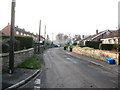
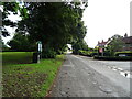
Common Lane, Scruton
The principal street through the village is a cul de sac at the eastern end. This view looks west towards the village centre.
Image: © Gordon Hatton
Taken: 19 Dec 2007
0.03 miles
2
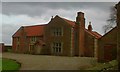
The Old Manor House
Built sometime before 1688 when the owners of the manor were the Gales. One of whom became Dean of York. It was replaced by a new house in 1705 which is across the Green. It is not listed because it has been altered too many times.
Image: © Matthew Hatton
Taken: 10 Jan 2014
0.11 miles
3
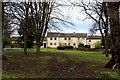
East End of the Village Green in Scruton
In need of a bit of grass seed. The byelaw requiring vehicles to keep off the village green appears to have been ignored
Image: © Chris Heaton
Taken: 20 Feb 2017
0.12 miles
4
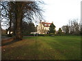
Village Green, Scruton
In the centre of this quiet village and fronting the churchyard.
Image: © Gordon Hatton
Taken: 19 Dec 2007
0.13 miles
6
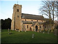
Church of St Radegund, Scruton
Village church just off the green. The tower is Perpendicular, whilst the main body of the church is a Victorian rebuild. The dedication to St Radegund is most unusual as there are apparently only 5 such churches in Britain. St Radegund was the daughter of a Thuringian king, born circa AD520 and died in 587. She is associated with the foundation of a convent at Poitiers in France.
Image: © Gordon Hatton
Taken: 19 Dec 2007
0.16 miles
7
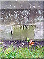
Benchmark on buttress of St Radegund's Church
Ordnance Survey cut mark benchmark described on the Bench Mark Database at http://www.bench-marks.org.uk/bm35834
Image: © Roger Templeman
Taken: 1 Sep 2013
0.16 miles
8
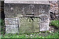
Bench Mark, St Radegund's Church
The cut mark is to be found on the east side of the church. For a view of the church Image and for further information on the bench mark http://www.bench-marks.org.uk/bm35834
A bench mark is an Ordnance Survey arrowhead sign found on walls, bridges, churches and specially erected triangulation pillars where the altitude above sea-level has been accurately measured by surveyors. The arrowhead points to a horizontal line above it which marks the exact altitude.
With rivets and pivots there is no datum (horizontal line) cut, the pointed-to horizontal surface defining the datum height.
Image: © Maigheach-gheal
Taken: 4 Oct 2010
0.16 miles
9
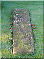
Grave cover, St Radegund's Church
At the north-east corner of the church there is a late 13th or early 14th grave cover which is heavily designed. It is much eroded but fortunately records have been kept as to the design.
Image: © Maigheach-gheal
Taken: 4 Oct 2010
0.16 miles
10
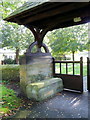
Lych gate and lych stone, St Radegund's Church
Many churches have a lych gate built over the main entrance to the enclosed area round the church. The name, also spelt lich or lytch, is from the Anglo Saxon 'lich' meaning corpse. The gate marks the division between consecrated and unconsecrated ground, where the bearers sheltered with the coffin, waiting for the clergyman to lead the procession before the burial. The original lych gates had seats, a lych cross and a lych stone - a slab on which the coffin rested.
Image: © Maigheach-gheal
Taken: 4 Oct 2010
0.16 miles