IMAGES TAKEN NEAR TO
Station Road, NORTHALLERTON, DL7 0QN
Introduction
This page details the photographs taken nearby to Station Road, DL7 0QN by members of the Geograph project.
The Geograph project started in 2005 with the aim of publishing, organising and preserving representative images for every square kilometre of Great Britain, Ireland and the Isle of Man.

There are currently over 7.5m images from over14,400 individuals and you can help contribute to the project by visiting https://www.geograph.org.uk
Image Map
Images are licensed for reuse under creativecommons.org/licenses/by-sa/2.0
Notes
- Clicking on the map will re-center to the selected point.
- The higher the marker number, the further away the image location is from the centre of the postcode.
Image Listing (17 Images Found)
Images are licensed for reuse under creativecommons.org/licenses/by-sa/2.0
Image
Details
Distance
1
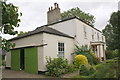
'The Anchorage', Scruton Lane
Previously known as 'Scruton Cottage' the house's garage carries an OS benchmark Image on the white-painted bricks to the right of the green doors
Image: © Roger Templeman
Taken: 1 Sep 2013
0.01 miles
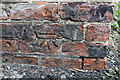
2
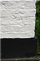
Overpainted benchmark at The Anchorage
Ordnance Survey cut mark benchmark described on the Bench Mark Database at http://www.bench-marks.org.uk/bm51192
Image: © Roger Templeman
Taken: 1 Sep 2013
0.01 miles
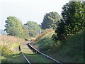
4
Level crossing, Scruton
The railway line is part of the Wensleydale Railway http://www.wensleydalerailway.com/
Image: © Maigheach-gheal
Taken: 4 Oct 2010
0.07 miles
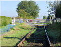
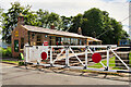
5
Scruton railway station and level crossing
Comparison with Image shows progress with building renovation and platform provision
Image: © Roger Templeman
Taken: 1 Sep 2013
0.07 miles
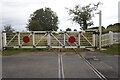
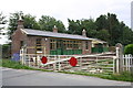
6
Level Crossing, Scruton Station
Scruton Lane Station was originally opened by the York, Newcastle and Berwick Railway on 6 March 1848 and later became known as Scruton Station. Used for goods, livestock and passengers, It was closed to passenger traffic by British Railways on 26 April 1954 with goods traffic continuing until 7 May 1956. It later fell into decay.
Despite the station's closure, the line remained open for limestone traffic until 1992 after which it was taken over by the Wensleydale Railway which obtained a lease of the 22 miles from Northallerton to Redmire. By the time the Wensleydale Railway opened in 2003, Scruton station was in a dilapidated and overgrown state. Restoration works were undertaken with the support of Scruton Parish Council and a grant from the Railway Heritage Trust. The station was fully restored and reopened by the Wensleydale Railway Trust in 2015.
Image: © David Dixon
Taken: 7 Jul 2021
0.07 miles
7
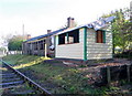
Old railway station, Scruton
This old station is to be found beside the Wensleydale Line which has not yet been restored.
Image: © Maigheach-gheal
Taken: 4 Oct 2010
0.08 miles
8
Level crossing, Scruton
The railway line is part of the Wensleydale Railway http://www.wensleydalerailway.com/
Image: © Maigheach-gheal
Taken: 4 Oct 2010
0.08 miles
9
Benchmark on Scruton Station building
Ordnance Survey cut mark benchmark described on the Bench Mark Database at http://www.bench-marks.org.uk/bm51191
Image: © Roger Templeman
Taken: 1 Sep 2013
0.08 miles
10
Scruton railway station and level crossing
There is an OS benchmark Image on the near building under the window to the left of the 30mph sign
Image: © Roger Templeman
Taken: 1 Sep 2013
0.08 miles