IMAGES TAKEN NEAR TO
Thrintoft, NORTHALLERTON, DL7 0QD
Introduction
This page details the photographs taken nearby to DL7 0QD by members of the Geograph project.
The Geograph project started in 2005 with the aim of publishing, organising and preserving representative images for every square kilometre of Great Britain, Ireland and the Isle of Man.

There are currently over 7.5m images from over14,400 individuals and you can help contribute to the project by visiting https://www.geograph.org.uk
Image Map
Images are licensed for reuse under creativecommons.org/licenses/by-sa/2.0
Notes
- Clicking on the map will re-center to the selected point.
- The higher the marker number, the further away the image location is from the centre of the postcode.
Image Listing (2 Images Found)
Images are licensed for reuse under creativecommons.org/licenses/by-sa/2.0
Image
Details
Distance
1
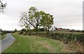
Thrintoft Moor Lane
Looking along the lane in the direction of Thrintoft, with Moor House farm visible in the middle distance.
Image: © Gordon Hatton
Taken: 26 Sep 2018
0.20 miles
2
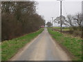
Country lane west of Yafforth.
This lane heads south from the B6271 towards Thrintoft. The tree in blossom is the entrance to Yafforth Grange.
Image: © Frank Glover
Taken: 16 Mar 2007
0.22 miles