IMAGES TAKEN NEAR TO
Station Road, NORTHALLERTON, DL7 0HH
Introduction
This page details the photographs taken nearby to Station Road, DL7 0HH by members of the Geograph project.
The Geograph project started in 2005 with the aim of publishing, organising and preserving representative images for every square kilometre of Great Britain, Ireland and the Isle of Man.

There are currently over 7.5m images from over14,400 individuals and you can help contribute to the project by visiting https://www.geograph.org.uk
Image Map
Images are licensed for reuse under creativecommons.org/licenses/by-sa/2.0
Notes
- Clicking on the map will re-center to the selected point.
- The higher the marker number, the further away the image location is from the centre of the postcode.
Image Listing (8 Images Found)
Images are licensed for reuse under creativecommons.org/licenses/by-sa/2.0
Image
Details
Distance
1
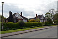
Bungalows, Station Road
Rather attractive small bungalows on the edge of this small community.
Image: © Tony Simms
Taken: 13 May 2015
0.00 miles
2
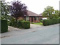
Bungalows on Station Road, North Cowton
Image: © Oliver Dixon
Taken: 23 Aug 2013
0.02 miles
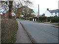
6
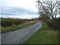
Heading south east into North Cowton
On Station Road.
Image: © JThomas
Taken: 14 Nov 2015
0.17 miles
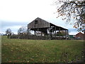
8
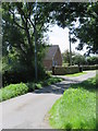
Lane and bridleway North Cowton
The lane is unnamed on maps, but the bridleway, which follows the same route is number 20.52/71, whilst the house is shown on the map as 'Clevelands'.
Image: © Gordon Hatton
Taken: 8 Aug 2020
0.22 miles