IMAGES TAKEN NEAR TO
Black Horse Lane, NORTHALLERTON, DL6 3ER
Introduction
This page details the photographs taken nearby to Black Horse Lane, DL6 3ER by members of the Geograph project.
The Geograph project started in 2005 with the aim of publishing, organising and preserving representative images for every square kilometre of Great Britain, Ireland and the Isle of Man.

There are currently over 7.5m images from over14,400 individuals and you can help contribute to the project by visiting https://www.geograph.org.uk
Image Map
Images are licensed for reuse under creativecommons.org/licenses/by-sa/2.0
Notes
- Clicking on the map will re-center to the selected point.
- The higher the marker number, the further away the image location is from the centre of the postcode.
Image Listing (25 Images Found)
Images are licensed for reuse under creativecommons.org/licenses/by-sa/2.0
Image
Details
Distance
1
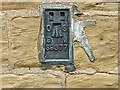
Swainby, Black Horse Farm
The OS Flush Bracket S9377 is embedded into the north-west face of the farmhouse, to the left of the front door.
Image: © Mel Towler
Taken: 28 May 2022
0.00 miles
2
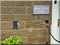
Swainby, Black Horse Farm
The OS Flush Bracket S9377 is embedded into the north-west face of the farmhouse, to the left of the front door.
Image: © Mel Towler
Taken: 28 May 2022
0.00 miles
3
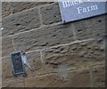
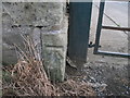
Flush bracket
Flush bracket used by Ordnance survey.
This flush bracket was used during the Third geodetic levelling, England & Wales. It was included on the Northallerton to Mickleby levelling line.
Image: © Michael Rye
Taken: 7 May 2017
0.02 miles
4
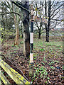
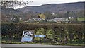
Direction Sign ? Signpost on Black Horse Lane, near Swainby
Located on the north side of Black Horse Lane, in a stand of trees between the road and the A172, opposite Black Horse Farm, in Whorlton parish. 1 arm and pawn finial. Black Horse Farm was formerly an inn on the drove road of which Hambleton Drove Road was part. The directions on the fingerpost are to Yarm and Stockton and the route is clear to see on old OS maps.
Milestone Society National ID: YN_NZ4702A
Image: © R Barron
Taken: 30 Mar 2022
0.02 miles
7
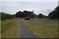
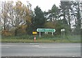
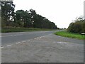
A172, Swainby
The Swainby bypass from the end of Black Horse Lane.
Image: © Richard Webb
Taken: 10 Aug 2016
0.04 miles
8
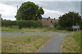
West Lees, Swainby
The end/start of Blackhorse Lane.
Image: © Richard Webb
Taken: 10 Aug 2016
0.06 miles
10
Ordnance Survey Cut Bench Mark
This Ordnance Survey mark was used as part of the levelling process for the OS map of 1890. The height recorded was 250.6ft above the mean sea level at Liverpool.
Image: © Michael Rye
Taken: 7 Jun 2017
0.08 miles