IMAGES TAKEN NEAR TO
Scugdale Road, NORTHALLERTON, DL6 3DR
Introduction
This page details the photographs taken nearby to Scugdale Road, DL6 3DR by members of the Geograph project.
The Geograph project started in 2005 with the aim of publishing, organising and preserving representative images for every square kilometre of Great Britain, Ireland and the Isle of Man.

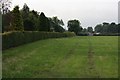
There are currently over 7.5m images from over14,400 individuals and you can help contribute to the project by visiting https://www.geograph.org.uk
Image Map
Images are licensed for reuse under creativecommons.org/licenses/by-sa/2.0
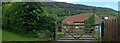
Notes
- Clicking on the map will re-center to the selected point.
- The higher the marker number, the further away the image location is from the centre of the postcode.
Image Listing (18 Images Found)
Images are licensed for reuse under creativecommons.org/licenses/by-sa/2.0
Image
Details
Distance
1
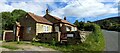
Swainby, Spring Garden
According to the OS benchmark database the cottage on the east side of the lane should have a benchmark cut into the extreme right of the property. This is a private residence and was unable to a check, but it is very likely the mark still exists. There are no visible alterations to the exterior of the property.
Image: © Mel Towler
Taken: 28 May 2022
0.11 miles
2
Shepherd Hill
A small hill leading down into Swainby.
Image: © Bill Boaden
Taken: 21 May 2015
0.13 miles
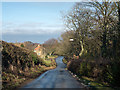
3
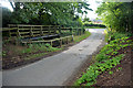
Swainby Ford
This ford is found on Scugdale Road in Swainby.
Image: © John Walton
Taken: 13 Sep 2015
0.13 miles
4
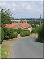
Shepherd Hill, Swainby
Looking down the hill at the edge of the village. The spire of Holy Cross Church is visible over the trees.
Image: © Gordon Hatton
Taken: 27 Jul 2022
0.13 miles
5
Course of Old Tramway, Near Mill Farm
Running along the edge of the field there is very little trace of the tramway now. It carried ore from the Ailesbury Ironstone Mines further up Scugdale down to the Cleveland and North Yorkshire Railway at Picton. Operations commenced in 1857 when the C&NYR opened and lasted thirty years.
Image: © Mick Garratt
Taken: 19 Jun 2007
0.13 miles
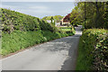
6
Road descending north into Swainby
Swainby is a village at the northern end of the North Yorks Moors National Park.
Image: © Trevor Littlewood
Taken: 6 Feb 2015
0.14 miles
7
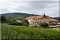
Cottages on the edge of Swainby
Displaying the characteristic colours of the area. Clain Wood rises up behind being the edge of Whorlton Moor.
Image: © Bill Boaden
Taken: 21 May 2015
0.17 miles
8
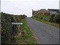
Approaching Heathwaite
Along Holgate. Millfield Farm is on the right.
Image: © Stephen McCulloch
Taken: 25 Oct 2007
0.18 miles
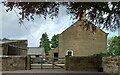
9
Swainby, Scarth Croft
According to the OS benchmark database there is a mark cut into the south face of the property. This is a private residence and I was unable to make a complete check. The exterior of the property appears to be unaltered and therefore it is likely the mark still exists.
Image: © Mel Towler
Taken: 28 May 2022
0.19 miles
10
Swainby, 136 High Street
There is a benchmark cut into the left hand corner of the gable end. The 2nd bar from the top of the wooden gate has obscured the benchmark!
Image: © Mel Towler
Taken: 28 May 2022
0.19 miles