IMAGES TAKEN NEAR TO
South End, NORTHALLERTON, DL6 3BP
Introduction
This page details the photographs taken nearby to South End, DL6 3BP by members of the Geograph project.
The Geograph project started in 2005 with the aim of publishing, organising and preserving representative images for every square kilometre of Great Britain, Ireland and the Isle of Man.

There are currently over 7.5m images from over14,400 individuals and you can help contribute to the project by visiting https://www.geograph.org.uk
Image Map
Images are licensed for reuse under creativecommons.org/licenses/by-sa/2.0
Notes
- Clicking on the map will re-center to the selected point.
- The higher the marker number, the further away the image location is from the centre of the postcode.
Image Listing (158 Images Found)
Images are licensed for reuse under creativecommons.org/licenses/by-sa/2.0
Image
Details
Distance
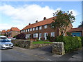
3
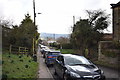
South End, Osmotherley
A reverse view of Image], with the lane to Thimbleby heading into the sun. Two of the cottages visible here are listed http://www.historicengland.org.uk/listing/the-list/list-entry/1150865 .
Image: © Derek Harper
Taken: 27 Dec 2015
0.02 miles
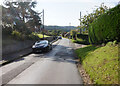
5
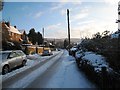
Snow-laden road in Osmotherley
This picture shows a view of the road that leaves Osmotherly in a southerly direction from the village green. A little further south the road splits into two; the left (easterly) fork goes towards Chequers and the right fork (south) goes to Thimbleby. On the horizon a part of Thimbleby Bank Plantation can be seen.
Image: © Philip Barker
Taken: 3 Jan 2010
0.03 miles
6
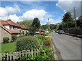
South End, Osmotherley
A reverse view of Image The lane from Thimbleby enters the village.
Image: © Derek Harper
Taken: 27 Dec 2015
0.03 miles
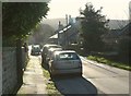
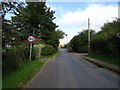
8
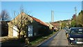
Road entering Osmotherley
The view is along the narrow road lined with individual houses towards the village centre; the road is known as South End.
Image: © Trevor Littlewood
Taken: 29 Jun 2014
0.04 miles
10

Osmotherley Village
From across the sheep pasture of Bulmer Hill with the tower of St. Peter's Church standing proud.
Image: © Mick Garratt
Taken: 2 Aug 2008
0.09 miles