IMAGES TAKEN NEAR TO
Oswaldene, NORTHALLERTON, DL6 3AD
Introduction
This page details the photographs taken nearby to Oswaldene, DL6 3AD by members of the Geograph project.
The Geograph project started in 2005 with the aim of publishing, organising and preserving representative images for every square kilometre of Great Britain, Ireland and the Isle of Man.

There are currently over 7.5m images from over14,400 individuals and you can help contribute to the project by visiting https://www.geograph.org.uk
Image Map (Loading...)


Getting Data...Please wait
Leaflet Map data © OpenStreetMap
Images are licensed for reuse under creativecommons.org/licenses/by-sa/2.0
Notes
- Clicking on the map will re-center to the selected point.
- The higher the marker number, the further away the image location is from the centre of the postcode.
Image Listing (139 Images Found)
Images are licensed for reuse under creativecommons.org/licenses/by-sa/2.0
Image
Details
Distance
1
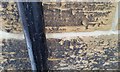
Ordnance Survey Cut Mark
This OS cut mark can be found on No58 West End. It marks a point 162.855m above mean sea level.
Image: © Adrian Dust
Taken: 1 Dec 2017
0.03 miles
4
Friends Meeting House Osmotherley
This appears to be the first time that the Friends Meeting House [Quakers] has been photographed for Geograph despite there being 165 other images in this square at the time of writing. The building does take some finding as it isn't signed from West End and is perched on the hillside just above what looks like a motor repair shop. The building is grade 2 listed and the listing states that it had been erected by 1733, which is odd as the date on the door lintel is 1723. The lean to extension is much newer and could date from 1947.
Image: © Gordon Hatton
Taken: 27 Jan 2022
0.07 miles
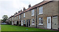
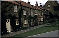
5
West End, Osmotherley in 1984
The house nearest to the camera, on the left, is The Old Police House while on the right is the tower of St Peter's church
Image: © John Baker
Taken: 21 Sep 1984
0.09 miles
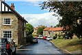
6
Still the same 60 years later
Taken by my late father in 1958, this shows this part of the village to hardly have changed since
Image: © Tony Whelan (Deceased)
Taken: Unknown
0.09 miles
7
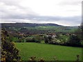
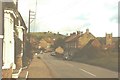
West End, Osmotherley
Heads due west out of the village towards the A19 dual carriageway - roughly a mile away.
Image: © Chris Heaton
Taken: 2 Jul 2022
0.11 miles
8
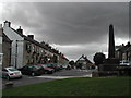
Osmotherley, North Yorkshire
"West End" with the Queen Catherine pub.
Image: © Tom Courtney
Taken: 2 Aug 2005
0.12 miles
9
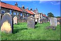
St. Peter's Churchyard
An oddly located church, tucked away behind the High Street. These cottages with their backs to the church have their frontages on the High Street. It's almost as if the village has turned its back on the church.
Image: © Mick Garratt
Taken: 29 Jul 2008
0.12 miles
10

The Golden Lion
Currently the only one of the three pubs in the village to feature in the Good Beer Guide. Pints of Timothy Taylors Landlord await thirsty walkers within.
Image: © Gordon Hatton
Taken: 5 Mar 2008
0.13 miles