IMAGES TAKEN NEAR TO
The Kennels, NORTHALLERTON, DL6 2LN
Introduction
This page details the photographs taken nearby to The Kennels, DL6 2LN by members of the Geograph project.
The Geograph project started in 2005 with the aim of publishing, organising and preserving representative images for every square kilometre of Great Britain, Ireland and the Isle of Man.

There are currently over 7.5m images from over14,400 individuals and you can help contribute to the project by visiting https://www.geograph.org.uk
Image Map
Images are licensed for reuse under creativecommons.org/licenses/by-sa/2.0
Notes
- Clicking on the map will re-center to the selected point.
- The higher the marker number, the further away the image location is from the centre of the postcode.
Image Listing (10 Images Found)
Images are licensed for reuse under creativecommons.org/licenses/by-sa/2.0
Image
Details
Distance
1
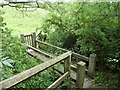
Bridge over Stream, West Rounton
This bridge is over an unnamed stream in a narrow wooded valley between West and East Rounton. A short distance beyond the bridge the stream flows into the River Wiske.
Image: © Paul Buckingham
Taken: 29 Aug 2010
0.09 miles
2
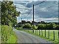
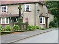
Track to Hurworth Hunt Kennels, West Rounton
The kennel buildings can be seen in the background. For more information about the hunt see http://www.hurworthhunt.co.uk/
Image: © Paul Buckingham
Taken: 29 Aug 2010
0.12 miles
3
St Lawrence's Church, East Rounton
The church has a window dedicated to Gertrude Bell, the daughter of the Teesside industrialist Hugh Bell, who became such a world expert on Mesopotamia that, after the First World War, she drew the boundaries of the new country of Iraq where she dies in 1926.
http://www.therountons.com/
Image: © Mick Garratt
Taken: 15 Oct 2005
0.18 miles
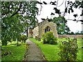
5
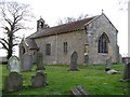
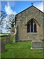
Church of St Lawrence, East Rounton
East Rounton is an even smaller village than its neighbour to the west, and like West Rounton it has a Victorian parish church. This one dates from 1884 and is of no great architectural merit.
Image: © Gordon Hatton
Taken: 4 Mar 2019
0.21 miles
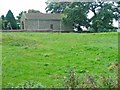
6
War Memorial, East Rounton
Situated on one side of The Square, a building comprising six cottages and the village hall set around an open lawn and built by Sir Isaac Bell, a wealthy Middlesbrough ironmaster.
Image: © Mick Garratt
Taken: 15 Oct 2005
0.24 miles
7
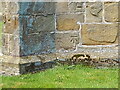
East Rounton, St Lawrence church
Benchmark on end wall, 2ft from ground
Image: © Mel Towler
Taken: 12 May 2021
0.24 miles
8
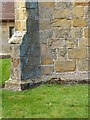
East Rounton, St Lawrence church
Benchmark
Image: © Mel Towler
Taken: 12 May 2021
0.24 miles
9
East Rounton, St Lawrence church
End wall as approach from road and footpath; BM on end wall, RHS 2ft above ground level
Image: © Mel Towler
Taken: 12 May 2021
0.24 miles
10

Cut Bench Mark East Rounton Bridge
This Ordnance survey mark was used as part of the levelling process for the OS map of 1911. The height recorded was 188.8ft above the mean sea level at Liverpool.
Image: © Michael Rye
Taken: 7 Jun 2017
0.25 miles