IMAGES TAKEN NEAR TO
East Rounton, NORTHALLERTON, DL6 2LE
Introduction
This page details the photographs taken nearby to DL6 2LE by members of the Geograph project.
The Geograph project started in 2005 with the aim of publishing, organising and preserving representative images for every square kilometre of Great Britain, Ireland and the Isle of Man.

There are currently over 7.5m images from over14,400 individuals and you can help contribute to the project by visiting https://www.geograph.org.uk
Image Map (Loading...)


Getting Data...Please wait
Leaflet Map data © OpenStreetMap
Images are licensed for reuse under creativecommons.org/licenses/by-sa/2.0
Notes
- Clicking on the map will re-center to the selected point.
- The higher the marker number, the further away the image location is from the centre of the postcode.
Image Listing (12 Images Found)
Images are licensed for reuse under creativecommons.org/licenses/by-sa/2.0
Image
Details
Distance
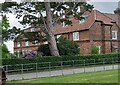
1
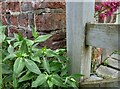
East Rounton, Home Farm
Roadside terraced brick built cottages attached to the Home Farm. This is the furthest left cottage showing the corner wall. Directly behind the wooden gatepost, about 1 foot from ground level there is a surveyor's cut mark, cut into the facing brick wall. The arrowhead of the benchmark is not clear.
Image: © Mel Towler
Taken: 13 Jun 2021
0.06 miles
2
East Rounton, Home Farm
Roadside terraced brick built cottages attached to the Home Farm. This is the furthest left cottage showing the corner wall. Directly behind the wooden gatepost, about 1 foot from ground level there is a surveyor's cut mark, cut into the facing brick wall. The arrowhead of the benchmark is not clear.
Image: © Mel Towler
Taken: 13 Jun 2021
0.06 miles
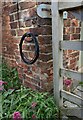
3
East Rounton, Home Farm
A wider angle of the roadside terraced brick built cottages attached to the Home Farm - taken from the entrance to Roots Farm shop. The furthest left cottage, the corner wall and directly behind the wooden gatepost, there is a surveyor's cut mark about 1 foot from ground level, cut into the facing brick wall. The arrowhead of the benchmark is not clear.
Image: © Mel Towler
Taken: 13 Jun 2021
0.06 miles
6
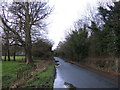
Track to The Gardens
The track is a Public Bridleway to Ingleby Arncliffe
Image: © Mick Garratt
Taken: 23 Mar 2007
0.12 miles
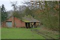
7
Ashmore, Benson, Pease and Co.’s tank at Rounton Grange
Rounton Grange, the ancestral home of the Bells, is now a bit of a no-show, given that the house was demolished back in 1965. The site’s now reverted to woodland. But a few buildings in the grounds are still hanging on. Like this one with an unmistakable cast iron tank proudly sporting the name of Ashmore, Benson, Pease and Co., which immediately cuaght my attention. And next door, there’s that strange ventilation arrangement. Curiouser and curiouser, as Alice once said.
So, here’s what we know. Sir Hugh Bell took the reins of the estate when his father died in 1904. The man wasted no time leaving his mark with fancy upgrades – private electricity and a spanking new water tank3. Could this be the said water tank, with the adjoining building housing the electricity gear? Oddly, Heritage Gateway, my trusty oracle for all things heritage, draws a blank.
In the photo, the low wall in the foreground surrounds some open tanks, hinting at some water treatment apparatus.
Now, let’s zoom in on that water tank on the nearby rooftop. The Ashmore, Benson, Pease and Co. tag triggers a memory for me, for I was once seconded at Davy-Ashmore, a descendent of that very company.
Four engineers and an ironmaster founded Ashmore, Benson, Pease and Company in Stockton-on-Tees in 1885, dealing in ironwork, gas engineering, and contracting4. In 1887, they won a major contract to build a new bridge, and the following year their catalog showcases gas-related products and infrastructure.
Fast forward to 1894, they’re on the up, scoring a contract for the Middlesbrough gas-holder, backed by none other than Alderman Hugh Bell. Two years later, the thing starts subsiding, but Bell insists it’s the foundation’s fault, not Ashmore, Benson, Pease and Co.
In 1901, the Power-Gas Corporation acquires them for their gas plant expertise, and by the start of the World War I, they’re well into manufacturing equipment for gas production, blast furnaces, and coke ovens.
So, in 1906, when this relatively modest tank was hoisted onto an outbuilding at Rounton Grange, Ashmore, Benson, Pease and Co. was the go-to company for gas engineering.
But to continue the brief history of the company, in 1960, it undergoes a merger, becoming part of the Davy-Ashmore group, and in ’68, the metal fabrication section of the business is acquired by Whessoe.
Ashmore, Benson, Pease and Company — an enterprise that’s endured for more than eight decades, began as an independent firm and eventually became absorbed by larger corporations, but left behind a legacy in the steel and energy sectors.
Now, the big question – is that a water tank or a gas tank?
For sources and supplementary photos see my journal http://www.fhithich.uk/?p=34829
Image: © Mick Garratt
Taken: 5 Mar 2024
0.19 miles
8
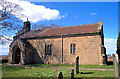
East Rounton, St Lawrence's Church ( another shot)
Image: © Bill Henderson
Taken: Unknown
0.21 miles
9
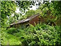
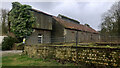
Derelict Barns, East Rounton
On the Rounton Grange estate. For more details about the demolished Rounton Grange see http://lh.matthewbeckett.com/houses/lh_yorkshire_rountongrange.html
Image: © Paul Buckingham
Taken: 29 Aug 2010
0.21 miles