IMAGES TAKEN NEAR TO
Sparrow Way, NORTHALLERTON, DL6 2GB
Introduction
This page details the photographs taken nearby to Sparrow Way, DL6 2GB by members of the Geograph project.
The Geograph project started in 2005 with the aim of publishing, organising and preserving representative images for every square kilometre of Great Britain, Ireland and the Isle of Man.

There are currently over 7.5m images from over14,400 individuals and you can help contribute to the project by visiting https://www.geograph.org.uk
Image Map
Images are licensed for reuse under creativecommons.org/licenses/by-sa/2.0
Notes
- Clicking on the map will re-center to the selected point.
- The higher the marker number, the further away the image location is from the centre of the postcode.
Image Listing (3 Images Found)
Images are licensed for reuse under creativecommons.org/licenses/by-sa/2.0
Image
Details
Distance
1

Halfway House, Brompton
Taken on Christmas Eve 2005 from the boundary of Northallerton Rugby Club - Ripon beat Northallerton!
Image: © Graham Hermon
Taken: 24 Dec 2005
0.09 miles
2
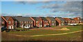
Little boxes
Part of the ever expanding residential development on the north side of Northallerton. Typical new houses crammed into small plots, and with a lack of imaginative design.
Image: © Gordon Hatton
Taken: 13 Jan 2023
0.17 miles
3
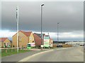
New housing development, Northallerton
The road here is part of the new link road between the A167 and A684 on the north side of the town, which will help to alleviate congestion at the Low Gates level crossing. It seems odd that a new housing estate is already being developed here before the relief road is open, and that such development will only lead to more traffic problems.
Image: © Gordon Hatton
Taken: 26 Sep 2018
0.22 miles