IMAGES TAKEN NEAR TO
Ashlands Court, NORTHALLERTON, DL6 1SW
Introduction
This page details the photographs taken nearby to Ashlands Court, DL6 1SW by members of the Geograph project.
The Geograph project started in 2005 with the aim of publishing, organising and preserving representative images for every square kilometre of Great Britain, Ireland and the Isle of Man.

There are currently over 7.5m images from over14,400 individuals and you can help contribute to the project by visiting https://www.geograph.org.uk
Image Map
Images are licensed for reuse under creativecommons.org/licenses/by-sa/2.0
Notes
- Clicking on the map will re-center to the selected point.
- The higher the marker number, the further away the image location is from the centre of the postcode.
Image Listing (24 Images Found)
Images are licensed for reuse under creativecommons.org/licenses/by-sa/2.0
Image
Details
Distance
1
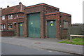
Electricity substation on Greenhowsyke Lane
There is an OS benchmark Image on the near side of the substation to the left of the grey downpipe
Image: © Roger Templeman
Taken: 15 Jul 2012
0.06 miles
2
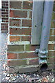
Benchmark on electricity substation, Greenhowsyke Lane
Ordnance Survey cut mark benchmark described on the Bench Mark Database at http://www.bench-marks.org.uk/bm44002
Image: © Roger Templeman
Taken: 15 Jul 2012
0.06 miles
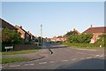
3
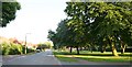
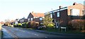
Valley Road
Taken from the junction with Linden road (on the right) and Central Drive (on the left). Houses built in the post-war surge in the early 1950s. The green on the left has two rows of trees that used to line a beck - a paradise for children. This has now been completely covered over. Nanny state?
Image: © Bob Embleton
Taken: 20 Jun 2007
0.07 miles
4
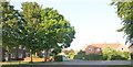
Central Drive
The inner of two concentric roads of 1950s council houses, built before many people needed garages.
Image: © Bob Embleton
Taken: 20 Jun 2007
0.10 miles
5
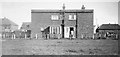
49, Linden Road, Northallerton
Photographed from the field that would soon become a building site.
The side view of the three-bedroomed, flat-roofed house.
Taken by my father before I was born.
My mother and two year-old brother stand in the doorway.
One of many post WW II housing estates of the early 1950s.
Image: © Garnet Embleton
Taken: Unknown
0.11 miles
6
Linden Road, Northallerton
The flat roofed houses were built in 1950/51, but many have been "improved" by the addition of more waterproof sloping roof. The downside is, one cannot sunbathe on the new roofs. I was born in number 49 and stayed there for the first 18.5 years of my life.
Image: © Bob Embleton
Taken: 16 Dec 2006
0.13 miles
7
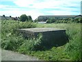
Air Raid Shelter, Back Lane, Linden Road, Northallerton
Top has been damaged. Steps lead down to the entrance doorway on this end. I was rescued from this by a policeman when I was 4! It became our stage when we charged local children a penny to see our shows like what William Brown did - and with similar success.
Image: © Bob Embleton
Taken: 17 Jun 2002
0.14 miles
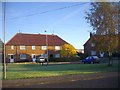
9
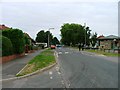
The Crescent
The outer of two concentric roads of 1950s council houses ending on Valley Road.
Image: © Bob Embleton
Taken: 20 Jun 2007
0.16 miles
10
Short Terraced Houses, The Crescent
Part of the 1950s post-war expansion of the council houses. Here three homes are attached. The planners had little concept of future car ownership. The small green provides a useful open space - enjoyed by all - especially the young.
Image: © Bob Embleton
Taken: 29 Oct 2008
0.16 miles