IMAGES TAKEN NEAR TO
Crosby Road, NORTHALLERTON, DL6 1FE
Introduction
This page details the photographs taken nearby to Crosby Road, DL6 1FE by members of the Geograph project.
The Geograph project started in 2005 with the aim of publishing, organising and preserving representative images for every square kilometre of Great Britain, Ireland and the Isle of Man.

There are currently over 7.5m images from over14,400 individuals and you can help contribute to the project by visiting https://www.geograph.org.uk
Image Map (Loading...)


Getting Data...Please wait
Leaflet Map data © OpenStreetMap
Images are licensed for reuse under creativecommons.org/licenses/by-sa/2.0
Notes
- Clicking on the map will re-center to the selected point.
- The higher the marker number, the further away the image location is from the centre of the postcode.
Image Listing (95 Images Found)
Images are licensed for reuse under creativecommons.org/licenses/by-sa/2.0
Image
Details
Distance
1
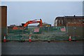
North Yorkshire Police HQ
When this site became available, the police HQ moved here from Newby Wiske Hall, a few miles to the south. The site now includes the local police station which moved here from a period building on the High Street. The view is from the end of a short street called 'The Link', which in times past was adjacent to the old prison site, with the result that jokers would change the name to 'The Clink'.
Image: © Gordon Hatton
Taken: 30 Jan 2024
0.01 miles
2

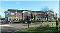
RPA building Northallerton
Rural Payments Agency, Crosby Road, Northallerton.
Government buildings.
Image: © Colin Grice
Taken: 12 May 2006
0.03 miles
4
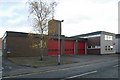
Northallerton fire station
Northallerton fire station, Crosby Road, Northallerton, North Yorkshire
Image: © Kevin Hale
Taken: 27 Nov 2006
0.06 miles
5
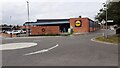
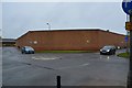
LiDL at junction of Crosby Road and The Link
Ordnance Survey records indicate that a benchmark levelled at 41.073m above Newlyn Datum was verified in 1974 on a wall then present at this location. See www.bench-marks.org.uk/bm32988
Image: © Roger Templeman
Taken: 12 Sep 2021
0.06 miles
6
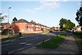
Crosby Road
The houses on the left overlook Mill Hill primary school on the right. The first pair of houses are modern, built upon Moody Bros (brothers) builders' yard. The other houses are much older - built in the days before people owned cars. The road up to the right was once just called "Back Lane" giving access to the rear of the properties and a field ( a childhood play area!). The field has recently been built upon, but the lane is still there.
Image: © Bob Embleton
Taken: 20 Jun 2007
0.07 miles
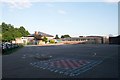
7
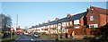
Terraced Houses in Crosby Road
Pre war houses once overlooked fields, but now Mill Hill School.
Image: © Bob Embleton
Taken: 16 Dec 2006
0.07 miles
8
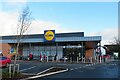
New Lidl store in Northallerton
The supermarket is on the site of the former prison, now referred to as the Treadmills retail park.
Image: © Gordon Hatton
Taken: 13 Jan 2023
0.08 miles
9
Mill Hill Primary School, Crosby Road
Opened in 1956 - I started there at the age of five at Easter, 1957. The hall had a flat roof which I now see has been converted to a pitched one.
Image: © Bob Embleton
Taken: 20 Jun 2007
0.08 miles