IMAGES TAKEN NEAR TO
Windsor Way, Quaker Lane, NORTHALLERTON, DL6 1FD
Introduction
This page details the photographs taken nearby to Windsor Way, Quaker Lane, DL6 1FD by members of the Geograph project.
The Geograph project started in 2005 with the aim of publishing, organising and preserving representative images for every square kilometre of Great Britain, Ireland and the Isle of Man.

There are currently over 7.5m images from over14,400 individuals and you can help contribute to the project by visiting https://www.geograph.org.uk
Image Map (Loading...)


Getting Data...Please wait
Leaflet Map data © OpenStreetMap
Images are licensed for reuse under creativecommons.org/licenses/by-sa/2.0
Notes
- Clicking on the map will re-center to the selected point.
- The higher the marker number, the further away the image location is from the centre of the postcode.
Image Listing (146 Images Found)
Images are licensed for reuse under creativecommons.org/licenses/by-sa/2.0
Image
Details
Distance
1
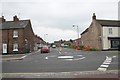
Entrance to Quaker Lane, Northallerton
Quaker Lane links the north end of the High Street A167 to Brompton Road A684 and can be used sometimes as a rat-run to avoid the heavier traffic in Friarage Street. I have never been able to find out why it is called Quaker Lane.
Image: © Bob Embleton
Taken: 18 Jun 2007
0.04 miles
2
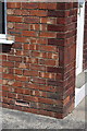
Benchmark on #17 Quaker Lane
Ordnance Survey cut mark benchmark described on the Bench Mark Database at http://www.bench-marks.org.uk/bm32857
Image: © Roger Templeman
Taken: 27 May 2012
0.05 miles
3
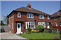
#17 Quaker Lane
There is an OS benchmark Image on the side front corner of the house
Image: © Roger Templeman
Taken: 27 May 2012
0.05 miles
4
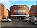
Church or cinema?
This was once a cinema just off Northallerton's High Street, but now it is the New Life Baptist Church.
Image: © Gordon Hatton
Taken: 30 Jan 2024
0.05 miles
5
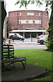
The Lyric Cinema
Taken from the church green. One of the most important buildings in a teenager's life in the 1960s. It opened on the 28th October 1939. In the late 1960s it was split into a dual-use building with a bingo hall in the "stalls" while the cinema (with a new widescreen) continued in the "circle" upstairs. It was bought in 1997 for £250,000 and converted into New Life Baptist Church opening on Easter Saturday, 11th April 1998. It looks as though it is now undergoing another change.
Image: © Bob Embleton
Taken: 18 Jun 2007
0.08 miles
6
All Saints church in Northallerton
The main Church of England church in this lovely town.
Image: © Jeremy Bolwell
Taken: 31 Jul 2021
0.08 miles
7
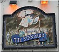
The Standard Pub Sign
The Battle of the Standard took place on 22nd August 1138 at a site north of Northallerton; see:Image
Image: © Bob Embleton
Taken: 18 Jun 2007
0.09 miles
8
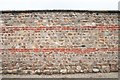
Wall
One piece of old wall left standing at the southern end of what is now Sainsbury's car park in the "north end" of Northallerton. I am curious as to the value of including brick courses amongst the cobbles. It could be that the wall was built in stages and the brick courses were to ensure it was built level.
John Webb adds (though this is not a flint-based wall): "The brickwork is included to strengthen the wall and link through from one side to the other. Flint-based walls need this strengthening to ensure they stand upright, as basically they are a heap of stones being held together by mortar - usually lime mortar rather than more modern cement."
Image: © Bob Embleton
Taken: 18 Jun 2007
0.10 miles
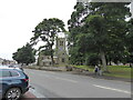
9
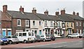
The Standard
A view of the east side of "north end" (that part of the High Street north of the church). The Standard pub has a sign Image linking its name to "The Battle of the Standard" though I don't recall that from my days of drinking here in 1970.
Image: © Bob Embleton
Taken: 18 Jun 2007
0.10 miles
10
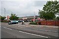
Sainsbury's, North End
Located at the far north end of the High Street near to the Low Gates level crossing on land that was once the railway marshalling yards.
Image: © Bob Embleton
Taken: 18 Jun 2007
0.10 miles