IMAGES TAKEN NEAR TO
Hutchinson Drive, NORTHALLERTON, DL6 1BQ
Introduction
This page details the photographs taken nearby to Hutchinson Drive, DL6 1BQ by members of the Geograph project.
The Geograph project started in 2005 with the aim of publishing, organising and preserving representative images for every square kilometre of Great Britain, Ireland and the Isle of Man.

There are currently over 7.5m images from over14,400 individuals and you can help contribute to the project by visiting https://www.geograph.org.uk
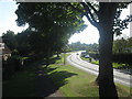
Image Map
Images are licensed for reuse under creativecommons.org/licenses/by-sa/2.0
Notes
- Clicking on the map will re-center to the selected point.
- The higher the marker number, the further away the image location is from the centre of the postcode.
Image Listing (32 Images Found)
Images are licensed for reuse under creativecommons.org/licenses/by-sa/2.0
Image
Details
Distance
3
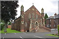
Roman Catholic Sacred Heart Church, Thirsk Road
There is an OS benchmark Image on the left side on the left hand side pinnacle column
Image: © Roger Templeman
Taken: 15 Jul 2012
0.11 miles
4
Benchmark on church on Thirsk Road
Ordnance Survey cut mark benchmark described on the Bench Mark database at http://www.bench-marks.org.uk/bm43999
Image: © Roger Templeman
Taken: 15 Jul 2012
0.11 miles
5
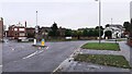
Junction of Thirsk Road (A168) and Racecourse Lane
The coach house of the former Unicorn & Turf Hotel was on the far side of the junction. Ordnance Survey records indicate that a benchmark was levelled on the building at 133.474 feet above Liverpool Datum during the 1842/5 1GL Selby to Newcastle-upon-Tyne Survey. The surveyor's description was: 'Branch Levelling from Mark No. 102. Mark on South-west corner of coach-house, at the Unicorn and Turf Hotel ; 1.43 ft. above pavement'
Image: © Roger Templeman
Taken: 5 Dec 2021
0.12 miles
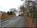
6
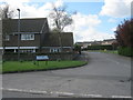
Entrance to South Vale in Northallerton
Image: © Peter Robinson
Taken: 15 Apr 2012
0.13 miles
7
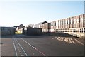
The buildings of Northallerton College from Mill Hill School
The playground of Mill Hill School in the foreground and the buildings of what was Northallerton Grammar school now Northallerton College. Mill Hill was my infant school when I was 5-8 years old. The grammar was my secondary school 11-18 years old.
Image: © Bob Embleton
Taken: 16 Dec 2006
0.15 miles
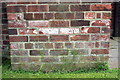
8
Benchmark on #74 Thirsk Road
Ordnance Survey cut mark benchmark described on the Bench Mark Database at http://www.bench-marks.org.uk/bm32986
Image: © Roger Templeman
Taken: 15 Jul 2012
0.15 miles
9
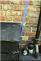
#74 Thirsk Road
There is an OS benchmark Image on the side of the house behind the black box
Image: © Roger Templeman
Taken: 15 Jul 2012
0.15 miles
10
Former Northallerton Grammar School
The school has had various titles over the years, including Northallerton College, but now the bell has rung for the last time, there will be no more detentions and no more visits to the head teacher's study for bad behaviour as the school has closed. The site is slowly becoming overgrown and this contributor is unaware of any plans for the site. Its proximity to the town centre would suggest that it could be prime development land for housing.
Image: © Gordon Hatton
Taken: 30 Jan 2024
0.16 miles