IMAGES TAKEN NEAR TO
Pinewood Crescent, NEWTON AYCLIFFE, DL5 6RR
Introduction
This page details the photographs taken nearby to Pinewood Crescent, DL5 6RR by members of the Geograph project.
The Geograph project started in 2005 with the aim of publishing, organising and preserving representative images for every square kilometre of Great Britain, Ireland and the Isle of Man.

There are currently over 7.5m images from over14,400 individuals and you can help contribute to the project by visiting https://www.geograph.org.uk
Image Map (Loading...)


Getting Data...Please wait
Leaflet Map data © OpenStreetMap
Images are licensed for reuse under creativecommons.org/licenses/by-sa/2.0
Notes
- Clicking on the map will re-center to the selected point.
- The higher the marker number, the further away the image location is from the centre of the postcode.
Image Listing (4 Images Found)
Images are licensed for reuse under creativecommons.org/licenses/by-sa/2.0
Image
Details
Distance
1
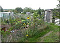
Allotments, Heighington
On the outskirts of the village in Highside Road.
Image: © pam fray
Taken: 19 Sep 2018
0.10 miles
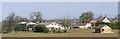
3
Highside Farm
There is a panorama over the far boundary which includes Darlington and the Cleveland hills.
In the 1841 census, the house was the family home of a local Registrar and farmer, William Wilkinson.http://www.g4fas.net/highside.html
Image: © Geoff Royle
Taken: 13 Jun 2007
0.22 miles
4
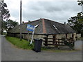
Converted barn for sale, Highside Road
Near Heighington.
Image: © pam fray
Taken: 19 Sep 2018
0.24 miles