IMAGES TAKEN NEAR TO
Emerson Way, NEWTON AYCLIFFE, DL5 5HG
Introduction
This page details the photographs taken nearby to Emerson Way, DL5 5HG by members of the Geograph project.
The Geograph project started in 2005 with the aim of publishing, organising and preserving representative images for every square kilometre of Great Britain, Ireland and the Isle of Man.

There are currently over 7.5m images from over14,400 individuals and you can help contribute to the project by visiting https://www.geograph.org.uk
Image Map
Images are licensed for reuse under creativecommons.org/licenses/by-sa/2.0
Notes
- Clicking on the map will re-center to the selected point.
- The higher the marker number, the further away the image location is from the centre of the postcode.
Image Listing (9 Images Found)
Images are licensed for reuse under creativecommons.org/licenses/by-sa/2.0
Image
Details
Distance
1
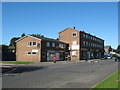
Simpasture Gate shops Newton Aycliffe
Built in the early 50's during the development of this County Durham New Town
Image: © Peter Robinson
Taken: 20 Sep 2009
0.13 miles
2

Playday children's nursery
Situated in the old part of Newton Aycliffe next to the disused steam railway line and old crossing.
Image: © tony jary
Taken: 28 May 2006
0.15 miles
3
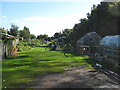
Finchale Road allotments
At the rear of Finchale Road housing in Newton Aycliffe County Durham
Image: © Peter Robinson
Taken: 20 Sep 2009
0.16 miles
4
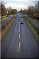
St Cuthbert's Way
From the bridge which once carried the Simpasture Branch of the London & North Eastern Railway and which is now a public cycleway/footpath.
Image: © Mick Garratt
Taken: 15 Dec 2008
0.20 miles
5

Canopus Club
Headquarters of Newton Aycliffe Branch of The Royal Air Forces Association.
Image: © Peter Robinson
Taken: 15 Jun 2009
0.23 miles
6

27b Watson Road in Newton Aycliffe County Durham
A semi-detached dwelling, one of a number of infill properties built after most of the B2 precinct was constructed in the early 1950's
Image: © Peter Robinson
Taken: 19 Aug 1993
0.23 miles
7

Disused railway bridge over St Cuthbert's Way
Image: © JThomas
Taken: 17 Nov 2012
0.25 miles
8
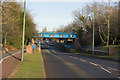
The Blue Bridge
The disused railway bridge over St Cuthberts Way (B6443) approaching Newton Aycliffe Town Centre.
Image: © Thomas Keetley
Taken: 6 Jan 2009
0.25 miles
9
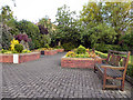
Memorial Garden
The memorial garden next to the War Memorial and parish church at Newton Aycliffe.
Image: © David Dixon
Taken: 23 Jun 2011
0.25 miles