IMAGES TAKEN NEAR TO
St. Georges Close, NEWTON AYCLIFFE, DL5 5ER
Introduction
This page details the photographs taken nearby to St. Georges Close, DL5 5ER by members of the Geograph project.
The Geograph project started in 2005 with the aim of publishing, organising and preserving representative images for every square kilometre of Great Britain, Ireland and the Isle of Man.

There are currently over 7.5m images from over14,400 individuals and you can help contribute to the project by visiting https://www.geograph.org.uk
Image Map
Images are licensed for reuse under creativecommons.org/licenses/by-sa/2.0
Notes
- Clicking on the map will re-center to the selected point.
- The higher the marker number, the further away the image location is from the centre of the postcode.
Image Listing (9 Images Found)
Images are licensed for reuse under creativecommons.org/licenses/by-sa/2.0
Image
Details
Distance
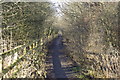
1
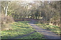
The Great Aycliffe Way
Another part of the Great Aycliffe Way in the direction of the Cricket Club.
Image: © Thomas Keetley
Taken: 8 Jan 2009
0.06 miles
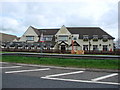
3
The Gretna Green
On the A167(T) near Newton Aycliffe. The original Hotel opened in the 1930s as the 'Gretna Green Wedding Inn'.
Image: © Hugh Mortimer
Taken: 21 Jun 2006
0.15 miles
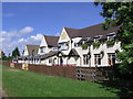
4
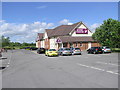
Travel Inn : Gretna Green Inn : Newton Aycliffe
Behind the Gretna Green Inn on the A167(T)
Image: © Hugh Mortimer
Taken: 21 Jun 2006
0.16 miles
5
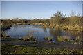
The Local Wild Life Pond
Local Wild Life Pond and Nature Reserve next to the old Railway track.
Image: © Thomas Keetley
Taken: 8 Jan 2009
0.17 miles
6
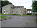
Sheltered housing
Gilpin Court, Gilpin Road, County Durham.
Image: © Peter Robinson
Taken: 15 Jun 2009
0.17 miles
7
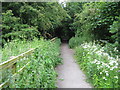
The Great Aycliffe Way
Part of the southern section of this route around Newton Aycliffe County Durham
Image: © Peter Robinson
Taken: 15 Jun 2009
0.18 miles
8
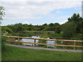
Newton Aycliffe Nature Park
Created by volunteers at the south east of the New Town in County Durham, the land was originally part of the WW2 Royal Ordnance Factory.
Image: © Peter Robinson
Taken: 15 Jun 2009
0.20 miles
9
The Great Aycliffe Way
The Great Aycliffe Way along the old Railway track which connected the Stillington branch and Bishop Auckland lines and once known as the "Wild Goose Line".
Image: © Thomas Keetley
Taken: 8 Jan 2009
0.24 miles