IMAGES TAKEN NEAR TO
Grindon Court, NEWTON AYCLIFFE, DL5 4RJ
Introduction
This page details the photographs taken nearby to Grindon Court, DL5 4RJ by members of the Geograph project.
The Geograph project started in 2005 with the aim of publishing, organising and preserving representative images for every square kilometre of Great Britain, Ireland and the Isle of Man.

There are currently over 7.5m images from over14,400 individuals and you can help contribute to the project by visiting https://www.geograph.org.uk
Image Map
Images are licensed for reuse under creativecommons.org/licenses/by-sa/2.0
Notes
- Clicking on the map will re-center to the selected point.
- The higher the marker number, the further away the image location is from the centre of the postcode.
Image Listing (7 Images Found)
Images are licensed for reuse under creativecommons.org/licenses/by-sa/2.0
Image
Details
Distance
1
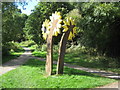
Sunflowers on the Great Aycliffe Way
On the eastern Woodham Burn section of the route in and around Newton Aycliffe County Durham
Image: © Peter Robinson
Taken: 20 Sep 2009
0.03 miles
2
Great Aycliffe Way Bridge
Straddling Woodham Burn in Newton Aycliffe and near a school providing an off-road route for pedestrians and cyclists
Image: © Peter Robinson
Taken: 20 Sep 2009
0.08 miles
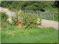
3
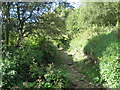
Subterranean Woodham Burn Newton Aycliffe
Normal summer appearance as the burn at this point is running below the limestone bed
Image: © Peter Robinson
Taken: 20 Sep 2009
0.11 miles
4
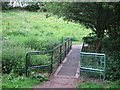
Footbridge over Woodham Burn in Newton Aycliffe
Image: © Peter Robinson
Taken: 15 Jun 2011
0.14 miles
6
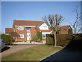
A house in Stoneleigh Court, Woodham
Newton Aycliffe.
Image: © Stanley Howe
Taken: 8 Mar 2010
0.21 miles
7

Access to Stoneleigh Court
From Lowther Drive, Woodham Village.
Image: © Stanley Howe
Taken: 9 Apr 2013
0.22 miles