IMAGES TAKEN NEAR TO
Rustland Drive, DARLINGTON, DL3 8EG
Introduction
This page details the photographs taken nearby to Rustland Drive, DL3 8EG by members of the Geograph project.
The Geograph project started in 2005 with the aim of publishing, organising and preserving representative images for every square kilometre of Great Britain, Ireland and the Isle of Man.

There are currently over 7.5m images from over14,400 individuals and you can help contribute to the project by visiting https://www.geograph.org.uk
Image Map
Images are licensed for reuse under creativecommons.org/licenses/by-sa/2.0
Notes
- Clicking on the map will re-center to the selected point.
- The higher the marker number, the further away the image location is from the centre of the postcode.
Image Listing (9 Images Found)
Images are licensed for reuse under creativecommons.org/licenses/by-sa/2.0
Image
Details
Distance
1
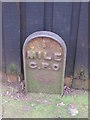
Old Milepost by the B6280, Conniscliffe Road, Darlington
Cast iron post by the B6280, in parish of Darlington (Darlington District), Conniscliffe Road, by Earlston House, East of junction with Linden Avenue in pavement, on South side of road. Darlington GPO iron post, erected by General Post Office in the 19th century, probably to assist with telegram delivery.
Inscription reads:-
1
MILE
G.P.O
Milestone Society National ID: DU_DAGPOc.
Image: © Milestone Society
Taken: 15 Mar 2017
0.07 miles
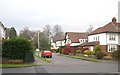
3
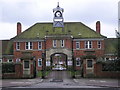
E.D.Walker Homes : Coniscliffe Road. Darlington
E.D.Walker Homes opened 1928. E.D.Walker (1842-1919) one time proprietor of the Northern Echo, and three times Mayor of Darlington.
Image: © Hugh Mortimer
Taken: 16 Mar 2006
0.08 miles
5
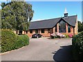
All Saints and Salutation Parish Church and Millennium Centre, Darlington
Image: © Bill Henderson
Taken: 23 Aug 2019
0.17 miles
6
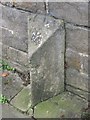
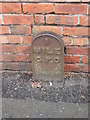
Old Boundary Marker by the A67, Carmel Road South, Darlington
Boundary Marker by the A67, in parish of Darlington (Darlington District), Carmel Road South, near Elm Ridge Methodist Church, against wall outside Greenways Mews.
Surveyed
Milestone Society National ID: DU_DAHLAbm
Image: © Milestone Society
Taken: Unknown
0.18 miles
7
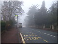
Blackwell Scar Darlington
A cul-de-sac in the Blackwell area of the town
Image: © Peter Robinson
Taken: 3 Dec 2009
0.22 miles
8
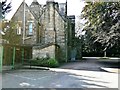
Elm Ridge Methodist Church, Darlington
Image: © Bill Henderson
Taken: 23 Aug 2019
0.22 miles
9
Old Milepost by Blackwell Lane, Darlington
Cast iron post by the B6280, in parish of Darlington (Darlington District), Blackwell Lane, opposite No. 78 against wall, on South side of road. Darlington GPO iron post erected by General Post Office in the 19th century, probably to assist with telegram delivery.
Inscription reads:-
1
MILE
G.P.O
Milestone Society National ID: DU_DAGPOb.
Image: © Milestone Society
Taken: 15 Mar 2017
0.23 miles