IMAGES TAKEN NEAR TO
Roman View, DARLINGTON, DL2 3TA
Introduction
This page details the photographs taken nearby to Roman View, DL2 3TA by members of the Geograph project.
The Geograph project started in 2005 with the aim of publishing, organising and preserving representative images for every square kilometre of Great Britain, Ireland and the Isle of Man.

There are currently over 7.5m images from over14,400 individuals and you can help contribute to the project by visiting https://www.geograph.org.uk
Image Map
Images are licensed for reuse under creativecommons.org/licenses/by-sa/2.0
Notes
- Clicking on the map will re-center to the selected point.
- The higher the marker number, the further away the image location is from the centre of the postcode.
Image Listing (111 Images Found)
Images are licensed for reuse under creativecommons.org/licenses/by-sa/2.0
Image
Details
Distance
1
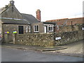
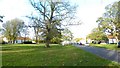
Houses surrounding Roman View, Piercebridge
The abodes illustrated in this picture lie at the north-western end of the village of Piercebridge. Roman View is the 'cobbled' street on the right-hand side of the picture and the B6275 is depicted in the left-hand bottom corner. The Carlbury Arms lies just north of here ( Image ).
Image: © Philip Barker
Taken: 13 Dec 2009
0.02 miles
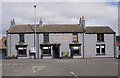
2
![Piercebridge houses [4]](https://s3.geograph.org.uk/geophotos/07/31/97/7319747_15835f85_120x120.jpg)
Piercebridge houses [4]
Now one house, number 2 The Green was originally three cottages in two early or mid 19th century builds. Constructed of painted, coursed rubble stone under a pantile roof. Listed, grade II, with details at: https://historicengland.org.uk/listing/the-list/list-entry/1121200
Piercebridge is a village in the county of Durham, some 5 miles west of Darlington. The village overlies a Roman fort built circa 265 where Dere Street, the Roman road from York to Newstead, crossed the River Tees. The fort was occupied until the fifth century and a civilian settlement was established to the east of the fort. The river has changed course and the remains of a Roman bridge over the river lie about a quarter of a mile east of the current bridge. Most of the site of the village is a Scheduled Ancient Monument, with details at: https://historicengland.org.uk/listing/the-list/list-entry/1002365
Image: © Michael Dibb
Taken: 23 Jun 2022
0.02 miles
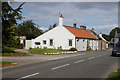
6
The Green, Piercebridge
Piercebridge is set around a roughly rectangular green which is within the outline of the Roman fort.
Image: © Gordon Hatton
Taken: 22 Oct 2017
0.03 miles
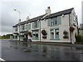
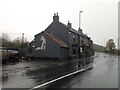
8
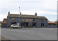
The Fox Hole, Piercebridge
Formerly the Carlbury Arms (see Image). Now repackaged in very sombre colours.
Image: © Oliver Dixon
Taken: 6 Mar 2015
0.03 miles
9
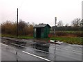
Bus stop and shelter, Piercebridge
On the B6275.
Image: © JThomas
Taken: 7 Nov 2015
0.03 miles
10
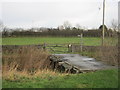
Farmers bridge carrying footpath over Piercebridge Beck
Image: © Peter Robinson
Taken: 20 Dec 2011
0.04 miles