IMAGES TAKEN NEAR TO
Piercebridge, DARLINGTON, DL2 3SZ
Introduction
This page details the photographs taken nearby to DL2 3SZ by members of the Geograph project.
The Geograph project started in 2005 with the aim of publishing, organising and preserving representative images for every square kilometre of Great Britain, Ireland and the Isle of Man.

There are currently over 7.5m images from over14,400 individuals and you can help contribute to the project by visiting https://www.geograph.org.uk
Image Map
Images are licensed for reuse under creativecommons.org/licenses/by-sa/2.0
Notes
- Clicking on the map will re-center to the selected point.
- The higher the marker number, the further away the image location is from the centre of the postcode.
Image Listing (3 Images Found)
Images are licensed for reuse under creativecommons.org/licenses/by-sa/2.0
Image
Details
Distance
1
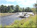
River Tees below High Coniscliffe
Shingle banks form where the river flows more rapidly.
Image: © Oliver Dixon
Taken: 10 Aug 2017
0.12 miles
2
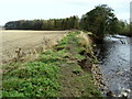
Riverbank Erosion on the Tees
Parts of the Teesdale Way long distance footpath are falling into the river through erosion, south of High Coniscliffe.
Image: © Chris Heaton
Taken: 4 Nov 2009
0.14 miles
3
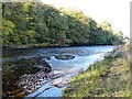
Swirling waters
Interesting frothy patterns on the Tees near High Coniscliffe.
Image: © Gordon Hatton
Taken: 27 Oct 2017
0.24 miles