IMAGES TAKEN NEAR TO
Martinsyde, DARLINGTON, DL2 1UF
Introduction
This page details the photographs taken nearby to Martinsyde, DL2 1UF by members of the Geograph project.
The Geograph project started in 2005 with the aim of publishing, organising and preserving representative images for every square kilometre of Great Britain, Ireland and the Isle of Man.

There are currently over 7.5m images from over14,400 individuals and you can help contribute to the project by visiting https://www.geograph.org.uk
Image Map
Images are licensed for reuse under creativecommons.org/licenses/by-sa/2.0
Notes
- Clicking on the map will re-center to the selected point.
- The higher the marker number, the further away the image location is from the centre of the postcode.
Image Listing (12 Images Found)
Images are licensed for reuse under creativecommons.org/licenses/by-sa/2.0
Image
Details
Distance

4
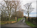
Route of the Original Darlington and Stockton Railway
Image: © Mick Garratt
Taken: 5 Nov 2005
0.16 miles
5
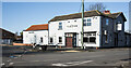
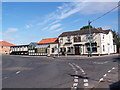
Platform 1 at Middleton St George
The pub, Platform 1, at Middleton St George was previously known as The Fighting Cocks. The rebranding reflects the history of the inn which was built in 1830 adjacent to the original route of the Stockton & Darlington Railway. That route has now been converted to a railway path.
There are moves, presumably currently on-going, (November 2020), to see the pub operate as a community asset; the village website tells more - https://middleton-st-george.org.uk/platform-1-fighting-cocks-a-community-owned-pub-for-middleton-st-george/
Image: © Trevor Littlewood
Taken: 19 Nov 2020
0.16 miles
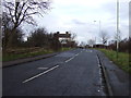
6
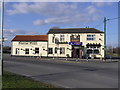
Fighting Cocks
The Fighting Cocks lies on the intersection of two ancient routes. The first running north/south is the Roman road of Rykenild Street which joined Humberside to Newcastle and crossed the River Tees a mile to the south. The second route is an old drovers road running from Carlisle to Yarm. In 1825 the Fighting Cocks Inn became the booking office of the Stockton to Darlington Railway.
Image: © Hugh Mortimer
Taken: 22 Mar 2006
0.17 miles
8
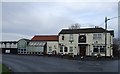
Fighting Cocks
Fighting Cocks pub in Middleton St George, showing the "George’s Restaurant" extension incorporating a converted railway carriage which reflects the connection with the history of the Stockton and Darlington Railway.
Image: © Adam Brookes
Taken: 22 Aug 2006
0.18 miles
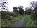
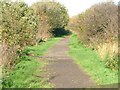
9
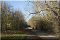
Railway path passing Middleton St. George
The footpath follows the route of the Stockton and Darlington Railway; this stretch is heading towards Darlington and the North Road Station. At this point a modern housing estate lies to the left of the grass; beyond the trees to the right is the Durham Wildlife Trust reserve known as The Whinnies.
Image: © Trevor Littlewood
Taken: 19 Nov 2020
0.20 miles