IMAGES TAKEN NEAR TO
West Roddymoor, CROOK, DL15 9QD
Introduction
This page details the photographs taken nearby to DL15 9QD by members of the Geograph project.
The Geograph project started in 2005 with the aim of publishing, organising and preserving representative images for every square kilometre of Great Britain, Ireland and the Isle of Man.

There are currently over 7.5m images from over14,400 individuals and you can help contribute to the project by visiting https://www.geograph.org.uk
Image Map
Images are licensed for reuse under creativecommons.org/licenses/by-sa/2.0
Notes
- Clicking on the map will re-center to the selected point.
- The higher the marker number, the further away the image location is from the centre of the postcode.
Image Listing (3 Images Found)
Images are licensed for reuse under creativecommons.org/licenses/by-sa/2.0
Image
Details
Distance
1
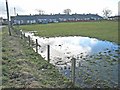
Fields north from West Roddymoor
West Roddymoor is a collection of houses at a junction of minor roads north-west of Crook; the view here is from the junction to the north where in the centre of the image lies the grey, exposed earth of an opencast coal mining operation.
Image: © Trevor Littlewood
Taken: 6 Sep 2011
0.13 miles
2
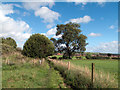
Footpath between fields west of Crook
Footpaths converge from three directions and meet at this location south of West Roddymoor; housing at the west side of the small town of Crook can be seen beyond the fields.
Image: © Trevor Littlewood
Taken: 6 Sep 2011
0.14 miles