IMAGES TAKEN NEAR TO
Douglas Terrace, CROOK, DL15 9JH
Introduction
This page details the photographs taken nearby to Douglas Terrace, DL15 9JH by members of the Geograph project.
The Geograph project started in 2005 with the aim of publishing, organising and preserving representative images for every square kilometre of Great Britain, Ireland and the Isle of Man.

There are currently over 7.5m images from over14,400 individuals and you can help contribute to the project by visiting https://www.geograph.org.uk
Image Map
Images are licensed for reuse under creativecommons.org/licenses/by-sa/2.0
Notes
- Clicking on the map will re-center to the selected point.
- The higher the marker number, the further away the image location is from the centre of the postcode.
Image Listing (23 Images Found)
Images are licensed for reuse under creativecommons.org/licenses/by-sa/2.0
Image
Details
Distance
1
Crook Town
B6298 from bridge over Crook Beck
Image: © norman griffin
Taken: 20 Sep 2006
0.06 miles
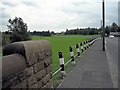
2
B6298 north of Crook
The Bishop Auckland & Weardale Railway used to run parallel with the road where there is now grass. Crook Station was located further down beyond where the old road joined with the end of Hope Street Image
Image: © Andrew Curtis
Taken: 4 Aug 2018
0.07 miles
3
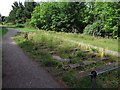
Sculpted railway sleepers, Deerness Valley Railway Path
Image: © Andrew Curtis
Taken: 4 Aug 2018
0.08 miles
5
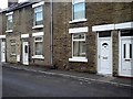
Crook Town
Terrace houses High Hope Street
Image: © norman griffin
Taken: 20 Sep 2006
0.14 miles
6
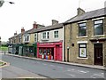
Shops at north end of Hope Street, Crook
Image: © Andrew Curtis
Taken: 4 Aug 2018
0.14 miles
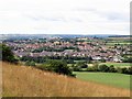
7
Deerness Trail Crook
View across to the Farriers Arms
Image: © norman griffin
Taken: 20 Sep 2006
0.14 miles
8
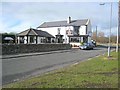
Farrers Arms, above Crook
A rare find! A pub that is open and serves food on a weekday lunchtime.
Image: © Oliver Dixon
Taken: 13 Feb 2007
0.15 miles
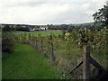
9
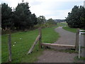
Deerness Valley Walk Crook
Start of the walk from the edge of Crook along the route of an old railway line.
Image: © norman griffin
Taken: 20 Sep 2006
0.17 miles
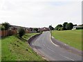
10
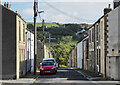
Wilson Street, Crook
Terraced housing on Wilson Street which is seen curving downhill, away from Hope Street
Image: © Trevor Littlewood
Taken: 1 Oct 2022
0.18 miles