IMAGES TAKEN NEAR TO
Park Avenue, CROOK, DL15 9HX
Introduction
This page details the photographs taken nearby to Park Avenue, DL15 9HX by members of the Geograph project.
The Geograph project started in 2005 with the aim of publishing, organising and preserving representative images for every square kilometre of Great Britain, Ireland and the Isle of Man.

There are currently over 7.5m images from over14,400 individuals and you can help contribute to the project by visiting https://www.geograph.org.uk
Image Map
Images are licensed for reuse under creativecommons.org/licenses/by-sa/2.0
Notes
- Clicking on the map will re-center to the selected point.
- The higher the marker number, the further away the image location is from the centre of the postcode.
Image Listing (44 Images Found)
Images are licensed for reuse under creativecommons.org/licenses/by-sa/2.0
Image
Details
Distance
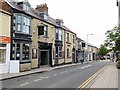
1
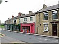
Shops at north end of Hope Street, Crook
Image: © Andrew Curtis
Taken: 4 Aug 2018
0.04 miles
2
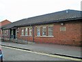
Crook Station Site
Crook Health Clinic built on what used to be the site of Crook Railway Station on the original Bishop Auckland and Weardale railway.
Image: © norman griffin
Taken: 20 Sep 2006
0.06 miles
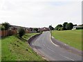
4
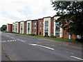
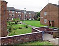
Apartment blocks on west side of B6298
Although these low-rise flats in Crook are off the B6298 they're probably accessed from Park Avenue Close.
Image: © Trevor Littlewood
Taken: 1 Oct 2022
0.09 miles
5
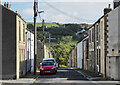
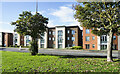
Wilson Street, Crook
Terraced housing on Wilson Street which is seen curving downhill, away from Hope Street
Image: © Trevor Littlewood
Taken: 1 Oct 2022
0.09 miles
7
Hope Street, Crook in vicinity of former station,1988
View SE: ex-NER Bishop Auckland - Tow Law line. Crook lost its service to Tow Law from 11/6/56, to Bishop Auckland from 8/3/65, the line being abandoned from 16/9/65.
Image: © Ben Brooksbank
Taken: 23 Jun 1988
0.10 miles
8
B6298 north of Crook
The Bishop Auckland & Weardale Railway used to run parallel with the road where there is now grass. Crook Station was located further down beyond where the old road joined with the end of Hope Street Image
Image: © Andrew Curtis
Taken: 4 Aug 2018
0.11 miles
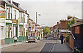
10
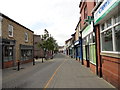
View down Hope Street, Crook
Looking south down this main shopping street in the town centre.
Image: © Robert Graham
Taken: 19 Jun 2015
0.12 miles