IMAGES TAKEN NEAR TO
Howden Le Wear, CROOK, DL15 8ED
Introduction
This page details the photographs taken nearby to DL15 8ED by members of the Geograph project.
The Geograph project started in 2005 with the aim of publishing, organising and preserving representative images for every square kilometre of Great Britain, Ireland and the Isle of Man.

There are currently over 7.5m images from over14,400 individuals and you can help contribute to the project by visiting https://www.geograph.org.uk
Image Map
Images are licensed for reuse under creativecommons.org/licenses/by-sa/2.0
Notes
- Clicking on the map will re-center to the selected point.
- The higher the marker number, the further away the image location is from the centre of the postcode.
Image Listing (8 Images Found)
Images are licensed for reuse under creativecommons.org/licenses/by-sa/2.0
Image
Details
Distance
1
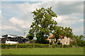
Gibbet Hills
Gibbet Hills is a farm close to the County Durham villages of Fir Tree and Howden-le-Wear; the macabre-naming theme continues - there's a bungalow just out of shot to the left - Hangman's Cottage!
Image: © Trevor Littlewood
Taken: 19 Jun 2013
0.02 miles
3
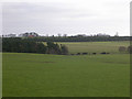
Field and Gibbet Hills from Douglas Lane
The farm at Gibbet Hills lies south-west of the small County Durham Town of Crook. The view is northwards from a minor road known as Douglas Lane and very close to the position of a now lost trig point known to the OS as 'Diggins'; it had flush bracket number S4212.
Image: © Trevor Littlewood
Taken: 22 Nov 2011
0.09 miles
4
Hangmans Cottage
Adjoining Gibbet Hills Farm near Howden le Wear County Durham
Image: © Peter Robinson
Taken: 6 Sep 2009
0.09 miles
5
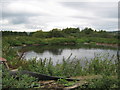
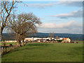
Farm pond
At Gibbet Hills Farm near Howden le Wear County Durham
Image: © Peter Robinson
Taken: 6 Sep 2009
0.09 miles
6

Douglas Lane westwards towards the A68
Image: © Peter Robinson
Taken: 10 Mar 2013
0.15 miles
7
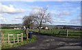
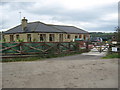
Gibbet Hills
Gibbet Hills Farm entrance, off Douglas Lane
Image: © Hugh Mortimer
Taken: 18 Feb 2007
0.17 miles
8
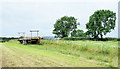
Trailer with telegraph poles
The trailer is just to the south of Douglas Lane, close to Witton-le-Wear. It's on the line of a public footpath and close to the location of a now missing trig point which was known to the OS as Diggins.
Image: © Trevor Littlewood
Taken: 30 Jul 2019
0.19 miles