IMAGES TAKEN NEAR TO
South Street, CROOK, DL15 0NH
Introduction
This page details the photographs taken nearby to South Street, DL15 0NH by members of the Geograph project.
The Geograph project started in 2005 with the aim of publishing, organising and preserving representative images for every square kilometre of Great Britain, Ireland and the Isle of Man.

There are currently over 7.5m images from over14,400 individuals and you can help contribute to the project by visiting https://www.geograph.org.uk
Image Map
Images are licensed for reuse under creativecommons.org/licenses/by-sa/2.0
Notes
- Clicking on the map will re-center to the selected point.
- The higher the marker number, the further away the image location is from the centre of the postcode.
Image Listing (11 Images Found)
Images are licensed for reuse under creativecommons.org/licenses/by-sa/2.0
Image
Details
Distance
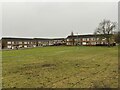
1
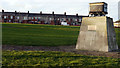
South Street, Willington
Willington is a former 'pit village' of County Durham; South Street's south side terrace of houses is seen across a grassed open space. The monument, topped by an old coal mine tub commemorates the 'Rocking Strike' of 1863. It was unveiled on 19 March 1976 by Joe Gormley, the then president of the NUM.
Image: © Trevor Littlewood
Taken: 7 Jan 2012
0.01 miles
2
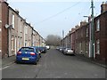
South Street, Sunnybrow
Victorian terraced houses in South Street, Sunnybrow, Willington. No doubt first developed to house workers at the nearby pit, now long gone.
Image: © Gordon Hatton
Taken: 13 Mar 2016
0.03 miles
3
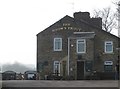
The Brown Trout, Willington
The pub appeared oddly quiet at lunchtime on a fine Sunday. The pub stands only a matter of yards away from what was once a busy coal mine, so no doubt miners' thirsts were quenched here.
Image: © Gordon Hatton
Taken: 13 Mar 2016
0.10 miles
4
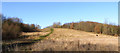
Broad path rising on slope above River Wear
The scene is not quite as rural as it appears; the path rises from close to the banks of the river towards the small town of Willington which is just over the brow of the slope.
Image: © Trevor Littlewood
Taken: 12 Jan 2020
0.17 miles
6
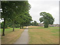
Brandon-Bishop Auckland Railway Walk in Sunnybrow
Image: © Peter Robinson
Taken: 21 Jul 2013
0.20 miles
8
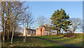
Houses at Sunnybrow
Sunnybrow is part of, or at least adjacent to the village (or small town) of Willington. The view is from the Brandon to Bishop Auckland Railway Walk which passes through Willington.
Image: © Trevor Littlewood
Taken: 12 Jan 2020
0.21 miles
9
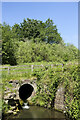
Willington Burn emerging from culvert
At the beginning of June the burn is just a trickle as it emerges from the culvert (which is at least partly brick-lined), but the diameter of the tunnel suggests that it was constructed with the possibility of a far greater flow in mind. Here, along the path of the Weardale Way the burn is close to its confluence with the River Wear.
Image: © Trevor Littlewood
Taken: 2 Jun 2023
0.21 miles
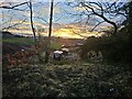
10
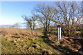
Ground beside Ian Bell Memorial Walk
The path of the memorial walk here is also part of the Weardale Way; it's adjacent to the River Wear which is just seen through the trees.
Ian Bell was an eight year old, swept away and drowned in the river in 2012. The sign in the image names the walk; it's in the blue and yellow colours typically found in County Durham naming towns and villages as roads enter. To see one naming a walk is unusual.
Image: © Trevor Littlewood
Taken: 12 Jan 2020
0.21 miles